 INDUSTRIAL
CHEMICALS AND TERRORISM: INDUSTRIAL
CHEMICALS AND TERRORISM:
HUMAN HEALTH THREAT ANALYSIS, MITIGATION AND
PREVENTION
Abstract
Terrorists, warring factions, and
saboteurs use chemicals commonly found in communities in industrialized nations to create
improvised explosives, incendiaries, and chemical agents. Common chemicals may be
used because standard military chemical agents may be difficult or dangerous to
manufacture, access, or disperse.
The Agency for Toxic Substances and Disease Registry (ATSDR)
developed a 10-step procedure to analyze, mitigate, and prevent public health hazards
resulting from terrorism involving industrial chemicals. The procedure includes
identifying key information such as potential threats, local sources of chemicals of
potential use to terrorists, exposure pathways, impacts on human health and
infrastructure, health risk communication needs, and mitigation and prevention methods.
The information identified during these steps is then incorporated into emergency response
plans and training exercises. Results of applying the 10-step procedure to two
communities are discussed.
Introduction
Terrorists sponsored by states, and
those with substantial financial resources and technical expertise, may purchase or
develop explosives, incendiaries and chemical agents similar to those used by military
services. However, several factors limit the use of these weapons by many terrorists,
including controlled access to precursor chemicals, difficulty and danger in producing the
agents, problems with dispersion of liquid droplets without military munitions, security
surrounding government chemical agent stockpiles, and binary chemical agent
storage. Industrial chemicals have been used by
terrorists as improvised explosives, incendiaries and poisons in several recent incidents2,3,4.
While the improvised chemical agents may be less toxic than military agents, many are
perceived by the public to be highly dangerous; they have rapid, highly visible impacts on
health; they are accessible; and they can be dispersed by smoke, gas clouds, or food and
medicine distribution networks.
In response to increasing concerns about chemical terrorism in
the United States, the Agency for Toxic Substances and Disease Registry developed a
10-step procedure to assist local public health and safety officials in analyzing,
mitigating and preventing such hazards5,6. Although the procedure was
used to address terrorism in the United States, it may be adapted to conflict zones where
industries become targets.
The purposes of this paper are to briefly describe the procedure,
and to describe some of the major findings when it was applied to two communities in the
United States: a large city in a desert with chemical and entertainment industries, and a
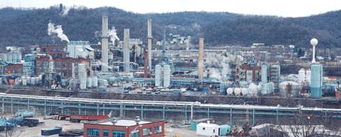
county containing several major chemical manufacturing facilities located along a river
valley.
Ten-Step Procedure
The procedures consists of the following steps:
1. Identify, assess and prioritize threats
2. Identify local sources of chemicals that may be used in
improvised weapons
3. Evaluate potential exposure pathways
4. Identify potential acute and chronic health impacts
5. Estimate potential impacts on infrastructure and the
environment
6. Identify health risk communication needs
7. Identify methods to mitigate potential hazards
8. Identify specific steps to prevent the use of industrial
chemicals as improvised weapons
9. Incorporate the threat assessment, mitigation, and
prevention information into emergency
response plans
10. Conduct training exercises to prepare to prevent and mitigate the
health threats.
Step 1: Identify, Assess and Prioritize Threats
As a starting point for the first step,
national statistics on domestic terrorism were reviewed to identify trends that may have
some relevance at the State and local levels7. Those statistics indicated
that:
 93% of the
incidents involved the use of explosives or incendiaries 93% of the
incidents involved the use of explosives or incendiaries
 75% of the
incidents occurred in two regions of the country 75% of the
incidents occurred in two regions of the country
 86% of the
groups focused on narrowly defined political issues with potential targets 86% of the
groups focused on narrowly defined political issues with potential targets
that could be identified in advance of an incident,
and
 43% of the
targets were businesses or industries, and another 50% involved government 43% of the
targets were businesses or industries, and another 50% involved government
staff or property.
The information on national trends
dispelled misconceptions about the nature of the threat, and provided strong guidance for
identifying and prioritizing threats at the local level. After reviewing the statistics,
potential threat groups were assessed based on several characteristics, including
potential targets and potential use of industrial chemicals as improvised weapons.
In both communities, terrorist groups in the immediate State or region were identified as
posing the greatest threats. These groups primarily targeted Federal government
infrastructure. However, some of the same groups also espoused a conservative religious
agenda, and might
target abortion clinics, gambling casinos, and nightclubs that they find offensive. One of
the multi-national corporations located in the river valley community had experienced a
chemical disaster at a plant in a foreign nation, resulting in thousands of deaths and
injuries. Potential retribution attacks by foreign terrorist groups were considered a
significant threat for that industrial facility and the surrounding community.
Step 2: Identify Local Sources of Chemicals Used in
Improvised Weapons
"Soft target" sources of chemicals in the
two communities mentioned above included:
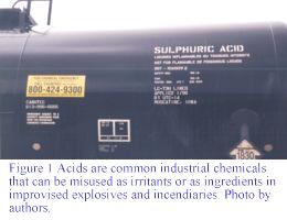  chemical manufacturing plants (chlorine, peroxides, other industrial gases, plastics, and
pesticides)
 food
processing and storage facilities with large ammonia tanks food
processing and storage facilities with large ammonia tanks
 chemical
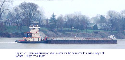
transportation assets (rail tank cars, tank trucks, pipelines, and river barges) chemical
transportation assets (rail tank cars, tank trucks, pipelines, and river barges)
 gasoline and
jet fuel storage tanks at distribution centers, airports, and barge terminals gasoline and
jet fuel storage tanks at distribution centers, airports, and barge terminals
 compressed gases in
tanks, pipelines, and pumping stations compressed gases in
tanks, pipelines, and pumping stations
 gold mines
where cyanide and mercury compounds are used gold mines
where cyanide and mercury compounds are used
 pesticide
manufacturing and supply distributors, and pesticide
manufacturing and supply distributors, and
 educational,
medical and research laboratories. educational,
medical and research laboratories.
Some of the more common types of chemicals that could be used in
improvised weapons in the communities included:
 eye, skin and
respiratory irritants (acids, ammonia, acrylates, aldehydes, and isocyanates) eye, skin and
respiratory irritants (acids, ammonia, acrylates, aldehydes, and isocyanates)
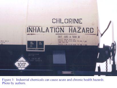
 choking agents
(chlorine, hydrogen sulfide, and phosgene) choking agents
(chlorine, hydrogen sulfide, and phosgene)
 flammable
chemical industry gases (acetone, alkenes, alkyl halides, amines) flammable
chemical industry gases (acetone, alkenes, alkyl halides, amines)
 aromatic
hydrocarbons that could be used as water supply contaminants (benzene, etc.) aromatic
hydrocarbons that could be used as water supply contaminants (benzene, etc.)
 oxidizers for
improvised explosives (oxygen, butadiene, and peroxides) oxidizers for
improvised explosives (oxygen, butadiene, and peroxides)
 aniline,
nitrile, and cyanide compounds that could be used as chemical asphyxiants aniline,
nitrile, and cyanide compounds that could be used as chemical asphyxiants
 compressed
hydrocarbon fuel gases that could be used as incendiaries or simple compressed
hydrocarbon fuel gases that could be used as incendiaries or simple
asphyxiants (liquified natural gas, propane,
isobutane)
 liquid
hydrocarbon fuels that could be used as incendiaries or water supply contaminants liquid
hydrocarbon fuels that could be used as incendiaries or water supply contaminants
(gasoline, jet fuel)
 industrial
compounds that could be used as blister agents (dimethyl sulfate), and industrial
compounds that could be used as blister agents (dimethyl sulfate), and
 organophosphate
pesticides that could be used as low-grade nerve agents. organophosphate
pesticides that could be used as low-grade nerve agents.
Step 3: Evaluate Exposure Pathways
Five components were evaluated for each potential
exposure pathway:
 the source of
the chemical (type, duration and magnitude of release) the source of
the chemical (type, duration and magnitude of release)
 delivery
methods (transportation routes; fate and transport in air and water; food and delivery
methods (transportation routes; fate and transport in air and water; food and
drug distribution networks)
 potential
targets (businesses and industries, government buildings, animal research potential
targets (businesses and industries, government buildings, animal research
laboratories, abortion clinics, etc.) and adjacent
affected areas
 exposure
routes (ingestion, inhalation, dermal, and ocular), and exposure
routes (ingestion, inhalation, dermal, and ocular), and
 receptor
populations, including sensitive sub-populations such as children, patients in receptor
populations, including sensitive sub-populations such as children, patients in
health care facilities, etc.
Communities with completed exposure pathways (i.e., all five
components were potentially present) were identified as high priorities for mitigation and
prevention efforts. Three important points were revealed during the pathways
analyses. First, unlike military chemical warfare, ingestion is a major exposure route in
chemical terrorism, particularly with cyanides, heavy metals, and liquid aromatic
hydrocarbons. Second, in both communities, chemical transportation assets posed greater
hazards than fixed facilities because substantial quantities of chemicals could be moved
closer to potential targets. Finally, it is critically important to identify sensitive
sub-populations within each potential receptor population, if possible. For example, in
the river valley community, several schools were located adjacent to a facility containing
acrylonitrile. Concentrations of acrylonitrile in air that are irritating to adults
can be lethal to children.
Step 4: Identify Potential Acute and Chronic Health
Hazards
Acute hazards are listed
explicitly or can be inferred from the information presented in Step 2. Detailed
information can be obtained from a number of government, academic, and commercial sources.
References used during the evaluations of the two communities in this paper included :
 the North
American Emergency Response Guide Book the North
American Emergency Response Guide Book
(http://hazmat.dot.gov/gydebook.htm)
 toxicological
profiles, chemical fact sheets, Case Studies in Environmental Medicine, and toxicological
profiles, chemical fact sheets, Case Studies in Environmental Medicine, and
Medical Management Guidelines published by ATSDR
(1-888-422-8737,
http://www.atsdr.cdc.gov/)
 fact sheets
from the U.S. Environmental Protection Agency (http://www.epa.gov) fact sheets
from the U.S. Environmental Protection Agency (http://www.epa.gov)
 material
safety data sheets from academia http://www.chem.utah.edu/MSDS) material
safety data sheets from academia http://www.chem.utah.edu/MSDS)
 commercial
hazardous substances databases such as TOMES by Micromedix. commercial
hazardous substances databases such as TOMES by Micromedix.
Potential chronic health effects from weapons that could be
improvised from sources in the two communities include:
 infections of
skin and lung burns, mental depression, and disabilities from incendiaries infections of
skin and lung burns, mental depression, and disabilities from incendiaries
and explosives
 chronic
conjunctivitis and permanent corneal damage from eye irritants chronic
conjunctivitis and permanent corneal damage from eye irritants
 respiratory
diseases (bronchitis, pneumonitis, chronic reduced airway flow) from choking respiratory
diseases (bronchitis, pneumonitis, chronic reduced airway flow) from choking
agents
 permanent
nerve damage, visual problems, muscle necrosis, psychiatric problems, and permanent
nerve damage, visual problems, muscle necrosis, psychiatric problems, and
memory loss from exposure to organophosphates
 heart, kidney
and liver damage from heavy metals, and heart, kidney
and liver damage from heavy metals, and
 increased
risks of birth defects from exposure to nitriles. increased
risks of birth defects from exposure to nitriles.
Cancer incidence would not be expected
to increase in either of the two communities evaluated in response to an acute exposure,
although communities are frequently concerned about relationships between chemical
exposures and cancers. Long-term medical monitoring would be needed for several of
the adverse health effects mentioned above in both communities.
Step 5: Identify Potential Infrastructure and
Environmental Impacts
Potential infrastructure impacts identified for the two
communities included:
 the need for
police, fire and ambulance crews to operate in contaminated environments the need for
police, fire and ambulance crews to operate in contaminated environments
 contamination
of hospital emergency rooms and staff contamination
of hospital emergency rooms and staff
 traffic jams
and damage to transportation infrastructure (roads, bridges, etc.) traffic jams
and damage to transportation infrastructure (roads, bridges, etc.)
 increased
risks of infectious diseases from lack of clean water, disruption of solid waste increased
risks of infectious diseases from lack of clean water, disruption of solid waste
disposal services, and contact with sewage from
broken pipes
 damage to or
contamination of government emergency operations centers damage to or
contamination of government emergency operations centers
 potential need
to divert law enforcement personnel to evacuate jail and prison inmates potential need
to divert law enforcement personnel to evacuate jail and prison inmates
 disruption of
electrical power, telephone, and computer services, and disruption of
electrical power, telephone, and computer services, and
 destruction,
damage, or contamination of houses, schools, and offices. destruction,
damage, or contamination of houses, schools, and offices.
Step 6: Identify Health Risk Communication Needs
During a major incident, elected
officials, the news media, and the public will demand credible information on health risks
from exposure to chemical agents, as well as information about casualties, traffic, school
children, etc. Health risk communication needs include fact sheets for high-priority
chemicals, a formal communications plan, risk communication training, and coordination
with law enforcement officials to protect sensitive information.
Step 7: Identify Methods to Mitigate Hazards
Specific steps to
mitigate potential hazards and impacts identified during the evaluations of the two
communities in this paper included stocking antidotes for cyanide, nitrile, aniline, and
organophosphate compounds; specifying alternate emergency operations centers,
transportation routes, and medical treatment facilities; preparing paper copies of
critical documents in case computer systems fail; and interagency coordination and
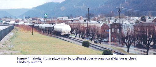
training exercises. In the river community, emergency response agencies had already
distributed "shelter-in-place" instructions to each household in the event of an
accidental release. Large electronic billboards in the entertainment section of the
desert city could be used for the same purpose. Hazardous materials control
infrastructure currently in place at the major chemical plants in the river valley
included trained and equipped hazardous materials response crews, a state-of-the-art
geographic information system containing detailed industrial chemical information,
redundant automated control systems, vapor cloud suppression equipment, expanded highways
along evacuation routes in neighborhoods adjacent to the plants, and earth barriers around
chemical storage tanks. This infrastructure would be effective in mitigating intentional
as well as accidental chemical releases.
Step 8: Identify Specific Steps to Prevent the Use of
Industrial Chemicals as Weapons
Standard industrial security measures
were reviewed with security staff from facilities and potential targets in the river
community. These included routine searches for suspect devices, anti-blast curtains or
film over windows, high-quality locks and alarms, bomb blankets to cover suspect devices,
video surveillance, metal detectors, separate entrance and exit points, bag check-in and
searches, security fencing, prohibiting unattended package deliveries, employee
identification badges, and decals for vehicles. Although routine security measures
at government buildings and abortion clinics were excellent, security at chemical plants
ranged from fair to very poor. Most security gaps were the result of complacency and lack
of awareness of the threat (i.e., that almost half of the targets were businesses and
industries). Chemical plant security managers were very pessimistic about their ability to
deter sabotage by employees, yet none of them had implemented simple background checks for
key employees such as chemical process operators. None of the corporate security staff had
been trained to identify combinations of common chemicals at their facilities that could
be used as improvised explosives and incendiaries, although most were aware of individual
chemicals that posed significant fire, explosion or poison hazards. Security around
chemical transportation assets ranged from poor to non-existent. Chemical barge
terminals were located along the banks of the chemical plants, and were freely accessible
along the river side of the facility. Rail and truck assets had no security beyond staging
areas. Rail cars containing cyanide compounds, flammable liquid pesticides, liquified
petroleum gases, chlorine, acids and butadiene were parked alongside residential areas.
Step 9: Incorporate Threat, Mitigation, and Prevention
Information into Response Plans
In the United States, chemical emergency
response plans are required by Federal law at the Federal, State and local government
levels. Most of the State and local plans currently do not address chemical terrorism, and
many of those that do focus on terrorist use of military nerve and blister agents, rather
than on the more accessible industrial chemicals. Information obtained during the threat,
mitigation, and prevention evaluations is being incorporated into emergency response plans
in the two communities.
Step 10: Train to Mitigate and Prevent Hazards
The final step is to train to respond to
high-priority, realistic threats. Training should include chemical protective equipment
for industrial as well as military chemical agents, victim decontamination and
transportation, hospital emergency room operations in a chemical environment, medical
management of chemical casualties from admission to discharge, victim registration
procedures, industrial security measures related to chemical terrorism, and hazardous
materials spill assessment and cleanup procedures in areas that are crime scenes and
require preservation of evidence. People generally respond to emergencies in the manner in
which they are trained. Failing to train to address the specific aspects of industrial
terrorism increases the vulnerabilities of industries and adjacent communities.
Conclusion
Industrial chemicals provide terrorists
with effective and readily accessible materials to develop improvised explosives,
incendiaries, and poisons. Many public and corporate emergency responders are unaware of
the magnitude of the threat of terrorism to businesses and industries. The procedure
described in this paper is one way to begin to address that threat. It is also adaptable
to industries that may become targets in conflict zones. Vigorous efforts are needed by
government personnel and corporate security experts to insure that these threats are
identified, and that attacks are mitigated, or better yet, prevented from occurring.
Authors
CDR Joseph L. Hughart
Mark M. Bashor
Agency for Toxic Substances and Disease Registry, U.S. Public Health Service
References
1) U.S. Department of Defense, Proliferation, Threat and
Response, April, 1996.
2) Hughart, Joseph L., Common Toxics and Terrorism, Proceedings
of the 1996 Southwest Counter-Terrorism Training Symposium, Nevada Department of Public
Safety, 1996.
3) Hughart, Joseph L., Terrorist Use of Expedient Chemical
Agents, XVth World Chemical Conference and NBC Symposium, U.S. Army Chemical Corps, FT
McClellan, AL, 1997.
4) U.S. Department of State, Patterns of Global Terrorism, 1995, http://nsi.org/Library/Terrorism/terror95.html
5) Hughart, Joseph L., Health Risk Assessment and Las Vegas Case
Study, Proceedings of the 1997 Annual Conference of the Nevada Public Health Association,
Las Vegas, NV
6) Hughart, Joseph L., Chemicals and Terrorism: Human Health
Threat Analysis, Mitigation and Prevention Information for Kanawha County and Nitro, West
Virginia, ATSDR, Atlanta, GA, 1998.
7) Federal Bureau of Investigation, Domestic Terrorism in the
United States, 1995, Washington, DC.
8) Stuempfle, A.K., et. al., Final Report of Task Force 25:
Hazard from Industrial Chemicals, U.S. Department of Defense, 18 March 1996.
9) Burke, Robert, Hazardous Materials Chemistry for Emergency
Responders, Lewis Publishers, Boca Raton, FL, 1997.
10) Sheridan, Rob, Brief Review of Smoke Inhalation Injury,
Shriner Burns Institute, Boston, MA, 1998.
11) ATSDR, Recent Evidence of Illnesses Linked to Exposure to
Hazardous Substances, ATSDR, Atlanta, GA, 1996.
12) Williams, Phillip L., and James Burson, Industrial
Toxicology, Van Nostrand Reinhold, New York, NY, 1985. |


