Wounded Knee: A Line in the Sand
Update 11/28/2014 - One interview & two new articles about the documentary:
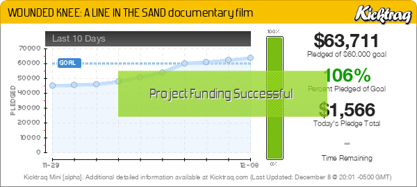
ALERT - WE MADE IT! the project raised $63,711 and is now fully funded thanks to all of you!!
Please consider making a donation for the completion of this important project by making a donation at Kickstarter.com now. Check out the presentation below. You can learn more about Kevin McKiernan here and you can view the trailer for the documentary below as well.
Wounded Knee: A Line in the Sand is an eyewitness account of the American Indian Movement's 1973 armed occupation of Wounded Knee and an exploration of how the long siege of that historic village changed Indian Country. The feature-length documentary presents the journey of two characters: Willard Carlson, a Yurok Indian fisherman who fought at Wounded Knee, and journalist Kevin McKiernan, the film's non-Indian director, who covered the controversial occupation from the inside.
Wounded Knee - A Line in the Sand Trailer from Kevin McKiernan on Vimeo.
ALERT - WE MADE IT! the project raised $63,711 and is now fully funded thanks to all of you!!

Also, check out the Huffington Post article, 1890 and 1973: Do We Really Know What Happened at Wounded Knee?.
You may wonder why I am posting about this documentary here on Mapcruzin. Here's the short answer. I've worked on many projects over the years. For the last 7 years I've been working with Willard Carlson, headman of the Blue Creek Ah Pah Traditional village on the Lower Klamath River in Northern California. Willard was a participant in the 1973 American Indian Movement standoff at Wounded Knee on the Pine Ridge Reservation in South Dakota and is an active participant in the documentary.
My work on the Blue Creek Ah Pah Traditional Yurok Village project has turned out to be some of the most important and personally satisfying work I have ever done. I began working with Willard in 2007. I've taken photos, helped with grant writing, tended a garden, built scale model Yurok Plankhouses for promotion and education, located old growth redwood, helped strategize... Soon I developed the BlueCreekAhPah.org website, created a brochure, authored web pages and helped with fund raising and educational presentations at various venues.
I learned that decades ago the Bureau of Reclamation had plans to build a dam at Ah Pah on the Klamath River. From the village site at Ah Pah I could see Thunder Mountain, the Klamath River and Blue Creek and could imagine a 700 foot dam there. I created maps of what the terrain would look like if the 700+ foot dam had been built. I found that the Klamath River would turn into a lake and extend 104 miles upstream from the village and flood many miles up the Trinity River as well, inundating Hoopa. Given the current drought and increased demand for water in California I wonder if they will once again look at the Lower Klamath River that runs through Yurok, Karuk and Hupa territory as a solution to the state's water shortages. You can check out the Ah Pah dam maps here.
Willard Carlson appears in the trailer at least twice. Makes me happy that he's wearing one of the t-shirts I had made for my Yurok Plank House project. An example of the scale Yurok Plank Houses that Ernie Albers and I created can be seen at the Clarke Museum in Eureka, CA.
Didn't find what you are looking for? We've been online since 1996 and have created 1000's of pages. Search below and you may find just what you are looking for.
Michael R. Meuser
Data Research & GIS Specialist
MapCruzin.com is an independent firm
specializing in GIS project development and data research.
We created the first U.S. based
interactive toxic chemical facility
maps on the internet in 1996 and we
have been online ever since. Learn more about us and our services.
Have a project in mind? If you have data, GIS project or custom shapefile needs contact Mike.
Contact Us
Report Broken Links
Subscribe for Updates
| 


