Back to SVTC EcoMaps
HomePage
The SVTC Groundwater Contamination Mapping and Environmental Justice Project has several
facets. These include: street level maps indicating groundwater contamination and
superfund sites, site reports, site-level demographic comparisons, and county-wide environmental justice
maps shaded to indicate demographic variation.
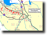
How to use the Upper Level County Map: The map name is indicated in the upper
right corner. If you have a javascript enabled browser (Netscape 3.0 and above or
Internet Explorer 4.0) you will see the name of the lower level map in the box as your
mouse pointer moves over the rectangles on the county map. Click on any rectangle
to zoom in to the street/site level.
You may do three things at this level:
- View the 3 county-wide demographic maps by clicking on "County-Wide Demographic Maps."
- Go to a list of all 179 sites, see a report and then view the map that the site is on by
clicking on "List of all 179 Sites by City."
- View any of 34 site/street level maps by clicking on a rectangle on the main map (above).
Site/Street Level Maps (zoomed in): When you click on a rectangle on the main map
(above) you will zoom-in to one of 34 site/street level maps.
You may do four things at this level:
- View a report associated with a site by clicking on a yellow or red icon.
- View a demographic chart that compares 9 demographic variables of the population
within 1/2 mile of the sites on this map to the county-wide demographics by clicking
on "Site Map Demographics" in the upper right corner of the screen.
- Move to any of the other 33 site/street level maps by pointing and clicking on the small map on the
right hand side. On this small map the green rectangle indicates your location on the
map of Santa Clara County.
- Zoom-out to the main map by clicking on "Return to Main Map" or by clicking
anywhere on the small map EXCEPT in a rectangle.
We want this to be a valuable resource for you. Please let us know what you like, what
you don't like, and where you would like to see improvements. Thank you.

