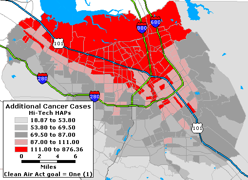
The above map shows the cummulative effect of 17 of Santa Clara County's leading 'High Tech' Hazardous Air Pollutants identified by SVTC that are contained in the CEP database and have an EPA Benchmark for cancer. The risk for cancer is much higher than the Clean Air Act goal of 1 in 1 million individuals anywhere in Santa Clara County. The cancer risk ranges from 18 to 876 additional cancer cases - a high of over 800 additional cancer cases per million individuals - resulting from exposure to the subset of High Tech chemicals that SVTC has identified.At this time we do not have the data that would allow us to determine the source (area, mobile, point, and background) for each of the 17 High Tech Haps. You may read more about the data we used and additional EPA data that we are requesting.
Please click to the right of the map to see chemical health information for these and the balance of the 34 High Tech pollutants identified by SVTC.
Website Created by
Michael R. Meuser, Clary-Meuser Research Associates