Alaska 2011 TRI GIS Shapefile Download Now Alabama 2011 TRI GIS Shapefile Download Now
Arkansas 2011 TRI GIS Shapefile Download Now
Arizona 2011 TRI GIS Shapefile Download Now
California 2011 TRI GIS Shapefile Download Now
Colorado 2011 TRI GIS Shapefile Download Now
Connecticut 2011 TRI GIS Shapefile Download Now
District of Columbia 2011 TRI GIS Shapefile Download Now
Delaware 2011 TRI GIS Shapefile Download Now
Florida 2011 TRI GIS Shapefile Download Now
Georgia 2011 TRI GIS Shapefile Download Now
Guam 2011 TRI GIS Shapefile Download Now
Hawaii 2011 TRI GIS Shapefile Download Now
Iowa 2011 TRI GIS Shapefile Download Now
Idaho 2011 TRI GIS Shapefile Download Now
Illinois 2011 TRI GIS Shapefile Download Now
Indiana 2011 TRI GIS Shapefile Download Now
Kansas 2011 TRI GIS Shapefile Download Now
Kentucky 2011 TRI GIS Shapefile Download Now
Louisiana 2011 TRI GIS Shapefile Download Now
Massachusetts 2011 TRI GIS Shapefile Download Now
Maryland 2011 TRI GIS Shapefile Download Now
Maine 2011 TRI GIS Shapefile Download Now
Michigan 2011 TRI GIS Shapefile Download Now
Minnesota 2011 TRI GIS Shapefile Download Now
Missouri 2011 TRI GIS Shapefile Download Now
Mississippi 2011 TRI GIS Shapefile Download Now
Montana 2011 TRI GIS Shapefile Download Now
North Carolina 2011 TRI GIS Shapefile Download Now
North Dakota 2011 TRI GIS Shapefile Download Now
Nebraska 2011 TRI GIS Shapefile Download Now
New Hampshire 2011 TRI GIS Shapefile Download Now
New Jersey 2011 TRI GIS Shapefile Download Now
New Mexico 2011 TRI GIS Shapefile Download Now
Nevada 2011 TRI GIS Shapefile Download Now
New York 2011 TRI GIS Shapefile Download Now
Ohio 2011 TRI GIS Shapefile Download Now
Oklahoma 2011 TRI GIS Shapefile Download Now
Oregon 2011 TRI GIS Shapefile Download Now
Pennsylvania 2011 TRI GIS Shapefile Download Now
Puerto Rico 2011 TRI GIS Shapefile Download Now
Rhode Island 2011 TRI GIS Shapefile Download Now
South Carolina 2011 TRI GIS Shapefile Download Now
South Dakota 2011 TRI GIS Shapefile Download Now
Tennessee 2011 TRI GIS Shapefile Download Now
Texas 2011 TRI GIS Shapefile Download Now
Utah 2011 TRI GIS Shapefile Download Now
Virginia 2011 TRI GIS Shapefile Download Now
Virgin Islands 2011 TRI GIS Shapefile Download Now
Vermont 2011 TRI GIS Shapefile Download Now
Washington 2011 TRI GIS Shapefile Download Now
Wisconsin 2011 TRI GIS Shapefile Download Now
West Virginia 2011 TRI GIS Shapefile Download Now
Wyoming 2011 TRI GIS Shapefile Download Now
Save! Purchase an entire region for $99.
Region 1 2011 TRI GIS Shapefile includes Connecticut, Massachusetts, Maine, New Hampshire, Rhode Island and Vermont
Download Region 1 Now
Region 2 2011 TRI GIS Shapefile includes New Jersey, New York, Puerto Rico, US Virgin Islands
Download Region 2 Now
Region 3 2011 TRI GIS Shapefile includes Delaware, District of Columbia, Maryland, Pennsylvania, Virginia and West Virginia
Download Region 3 Now
Region 4 2011 TRI GIS Shapefile includes Alabama, Florida, Georgia, Kentucky, Mississippi, North Carolina, South Carolina and Tennessee
Download Region 4 Now
Region 5 2011 TRI GIS Shapefile includes Illinois, Indiana, Michigan, Minnesota, Ohio and Wisconsin
Download Region 5 Now
Region 6 2011 TRI GIS Shapefile includes Arkansas, Louisiana, New Mexico, Oklahoma and Texas
Download Region 6 Now
Region 7 2011 TRI GIS Shapefile includes Iowa, Kansas, Missouri and Nebraska
Download Region 7 Now
Region 8 2011 TRI GIS Shapefile includes Colorado, Montana, North Dakota, South Dakota, Utah and Wyoming
Download Region 8 Now
Region 9 2011 TRI GIS Shapefile includes Arizona, California, Hawaii, Nevada and Guam
Download Region 9 Now
Region 10 2011 TRI GIS Shapefile includes Alaska, Idaho, Oregon and Washington
Download Region 10 Now
Return Policy
 ClickBank will, at its discretion, allow for the return or replacement of any product within 60 days from the date of purchase.
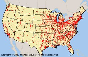
A Note About How Your GIS Maps Will Look
The image on this page is an example of how these shapefiles may look when loaded into a GIS program. Your GIS maps may not look exactly like this. Each GIS program is different. Shapefiles themselves are a collection of points, lines or polygons. They have no attributes. It is up to you, the user, to define colors, line width, symbols and other attributes within the limits and capabilities of the GIS programs you are using.
Copyright and Use of Shapefiles
The shapefiles on this page are copyrighted as follows. Copyright © 2012 Michael R. Meuser, All Rights Reserved. You may use these shapefiles in any GIS project or to make maps. You may not create copies of the shapefiles for the use of others whether for personal or commercial use. You may not resell the shapefiles. If you require multiple copies of the same shapefile, please contact Mike at [email protected]. Thank You.
About Quality, Accuracy and Suitability
Specifically, we were able to map 2,176,280 data point records from the latest GNIS data. We were not able to map 69,207 records because they lacked the necessary longitude and latitude. What this means is that we were able to convert 96.82% of the data into shapefiles while we were not able to convert 3.8% of the data. Those records not mapped are available to you in the following formats: Open Office Calc, MS Excel and DBF.
Generally, the geodata and shapefiles found at MapCruzin.com may come from a variety of
government, non-governmental and self-reporting private
sources. While we try to assure the accuracy of
this material, we cannot promise that it is
absolutely accurate. We do promise that using the
map layer will be fun, entertaining or educational - possibly even frustrating.
Beyond this, we make no guarantee as to its
suitability for any purpose. We assume no liability
or responsibility for errors or inaccuracies. Please
understand that you download and use these map layers and data at your own
risk.
<-- Return to Do It Yourself GIS Maps
Didn't find what you are looking for? We've been online since 1996 and have created 1000's of pages. Search below and you may find just what you are looking for.
Michael R. Meuser
Data Research & GIS Specialist
MapCruzin.com is an independent firm
specializing in GIS project development and data research.
We created the first U.S. based
interactive toxic chemical facility
maps on the internet in 1996 and we
have been online ever since. Learn more about us and our services.
Have a project in mind? If you have data, GIS project or custom shapefile needs contact Mike.
Contact Us
Report Broken Links
Subscribe for Updates