|
Check out our GIS Books and Products store
GIS Shapefiles
For Beginners & Experienced GIS Users Alike
Skip to Toxic Release Inventory TRI Shapefiles - Canadian FSA Postal Code Shapefiles - Geographic Names Information System Shapefiles - Zip Code Boundary Shapefiles with Demographics - U.S. 2010 Census Zip Code Boundary Shapefiles - U.S. Nuclear Energy Facilities - U.S. Streams, Rivers, Waterways - U.S. Waterbodies and Wetlands - U.S. School District Shapefiles - Tornado Shapefiles - Dams and Risk of Failure - Indian & Federal Lands Shapefiles
Beginners Create Digital GIS Maps in Minutes
 Now you can learn digital mapping. Add value to your education, job or business with GIS (geographic information systems). Each GIS map layer includes easy to follow instructions that show you how to add streets, highways, census information and much more to your maps for free. Each of the shapefile map layers also includes free access to our Learn2Map GIS Tutorial and Atlas and free GIS software so that you can begin creating GIS map projects in minutes. If you are new to GIS, learn more about it here.
GIS Professionals
If you are already using GIS, these shapefiles work with ArcView GIS, ArcGIS, Maptitude, Mapinfo, Manifold and many other commercial GIS and mapping programs and many free GIS programs as well. We have included several base shapefile map layers with each map archive listed below. In addition, we have many free GIS shapefiles that you may wish to add to your digital maps.
 Indian & Federal Lands
ArcGIS Shapefiles
Map Layers
Includes:
- Bureau of Indian Affairs (BIA) GIS Shapefile Map Layer
- Bureau of Land Management (BLM) GIS Shapefile Map Layer
- Bureau of Reclamation (BOR) GIS Shapefile Map Layer
- Department of Defense (DOD) GIS Shapefile Map Layer
- Fish & Wildlife Service (FWS) GIS Shapefile Map Layer
- Forest Service (FS) GIS Shapefile Map Layer
- National Park Service (NPS) GIS Shapefile Map Layer
Each GIS map layer includes other federal lands, not listed above, and base layers including cities, roads, rivers, states and water bodies. Click here for details.
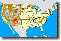
 Toxic Release Inventory Shapefiles Based
on Latest October, 2014 EPA Dataset
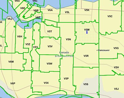 Canada Forward Sortation Areas
(FSA) Postal Code Shapefiles
 U.S. Geographic Names
Information System (GNIS)
Shapefiles Based on USGS GNIS
Data Updated 10/1/2012
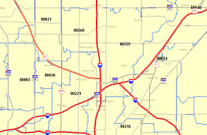
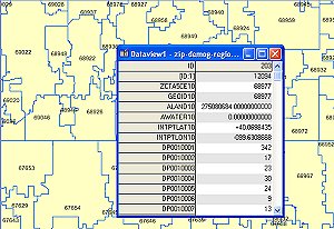 Zip Code Boundary Shapefiles with
Demographics Based on 2010 U.S. Census Data
 Discount U.S. Zip Code Boundary Shapefiles
Based on 2010 U.S. Census Data
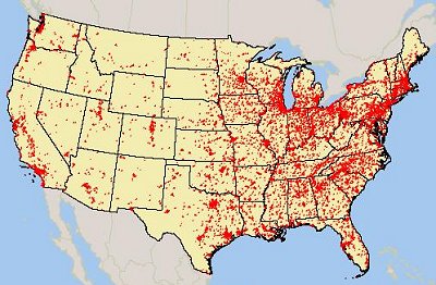
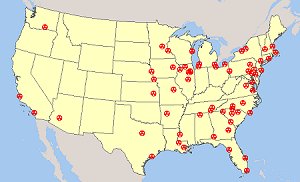 Nuclear Energy Facilities in the U.S.
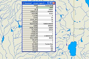 U.S. Streams, Rivers and Waterway GIS Shapefiles
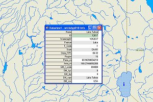 U.S. Waterbody and Wetlands Shapefile
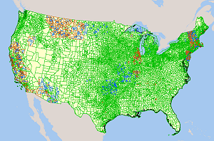 U.S. Elementary, Secondary
and Unified School District Shapefiles
Each of the school district GIS map layers is derived from the latest U.S. census 2010 data. School districts are included for all 50 U.S. states plus Puerto Rico. Each shapefile includes access to free GIS base files. You can download all 3 school district shapefiles immediately.
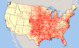 U.S. Tornadoes from 1950 through 2008 Shapefiles
The Storm Prediction Center (SPC), one of the National Centers for Environmental Prediction, studies severe and dangerous weather, including heavy rain and snow, fire weather events, thunderstorms, and tornadoes. The SPC uses advanced technology to provide tornado forecasts, watches, and warnings for the conterminous United States, as well as other tornado information used by many groups, such as weather forecasters, emergency managers, and the aviation industry. As part of their research, the SPC compiles tornado statistics from data in the Tornado/Severe Thunderstorm Database and from National Weather Service storm data.
The United States Tornado Touchdown Points 1950-2008 map layer includes tornado touchdown points for tornadoes that occurred in the United States, Puerto Rico, and the U.S. Virgin Islands. Descriptive information includes the latitude and longitude of the touchdown and lift-off points, the number of fatalities or injuries, an estimate of damage costs, and the classification of the storm on the Fujita Tornado Damage Scale.
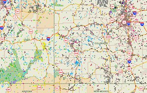
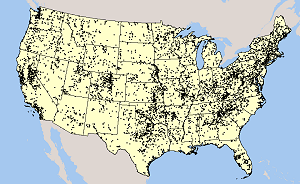 U.S. Dams - Name, Location,
Risk-Level, Purpose
and Type of Dam
The Major Dams of the United States map layer is a subset of the 2005 National Inventory of Dams, extracted by the National Atlas of the United States�. It lists and describes more than 8,100 major dams in the United States, Puerto Rico, and the U.S. Virgin Islands. Major dams include dams 50 feet or more in height, dams with a normal storage capacity of 5,000 acre-feet or more, and dams with a maximum storage capacity of 25,000 acre-feet or more. Descriptive information includes the dam name and location, the risk level associated with the dam, the purposes for which the dam was constructed, and the dam type.
With these detailed shapefiles you can learn more about dams and their condition anywhere in the United States.
No Experience Required
The shapefiles come with easy to follow instructions for downloading ArcExplorer, a free GIS map viewer. We provide step-by-step instructions so that you can easily learn to use and view the maps. For more help, each shapefile is packaged with our Learn2Map GIS Tutorial & Atlas.
A Note About How Your GIS Maps Will Look
The image(s) on this page are examples of how these shapefiles may look when loaded into a GIS program. Your GIS maps may not look exactly like this. Each GIS program is different. Shapefiles themselves are a collection of points, lines or polygons. They have no attributes. It is up to you, the user, to define colors, line width, symbols and other attributes within the limits and capabilities of the GIS programs you are using.
About Quality, Accuracy and Suitability
This data may come from a variety of
government and self-reporting private
sources. While we try to assure the accuracy of
this material, we cannot promise that it is
absolutely accurate. We do promise that using the
map layer will be fun, entertaining or educational.
Beyond this, we make no guarantee as to its
suitability for any purpose. We assume no liability
or responsibility for errors or inaccuracies. Please
understand that you use these map layers and data at your own
risk.
Thank You,
Didn't find what you are looking for? We've been online since 1996 and have created 1000's of pages. Search below and you may find just what you are looking for.
Michael R. Meuser
Data Research & GIS Specialist
MapCruzin.com is an independent firm
specializing in GIS project development and data research.
We created the first U.S. based
interactive toxic chemical facility
maps on the internet in 1996 and we
have been online ever since. Learn more about us and our services.
Have a project in mind? If you have data, GIS project or custom shapefile needs contact Mike.
Contact Us
Report Broken Links
Subscribe for Updates
|


