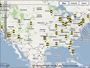
Map of the Nation's 101 Most Dangerous Chemical Facilities. Millions at Risk.
<-- Chemical Terrorism and Security
Source: American Progress

Visit the 101 Most Dangerous Chemical Facilities Interactive Maps.
This map shows the locations of the nation's 101 most dangerous chemical facilities, each of which threatens some 1 million or more people. The vast majority of these facilities could convert to safer, more secure chemicals or processes.
Click on an icon to see the facility name, the process it currently uses, and potential alternatives it could adopt. In a number of cities, multiple facilities are located very close to each other. Zoom in on the map to view these facilities.
Most of the nation's 101 most dangerous chemical facilities could become less attractive terrorist targets by converting to alternative chemicals or processes. Doing so would improve the safety and security of the more than 80 million Americans who are living within range of a worst-case toxic gas release from one of these facilities, according to data compiled by Paul Orum and Reece Rushing in the report "Chemical Security 101: What You Don't Have Can't Leak, or Be Blown Up by Terrorists."
Visit the 101 Most Dangerous Chemical Facilities Interactive Maps.
Related Articles, Reports and Resources
Congress Deliberating HR 2868 - the Chemical Facilities Anti-Terrorism Act of 2009.
Chemical Security Legislation Clears Key House Subcommittee.
Chemical Security & Drinking Water Security Legislation Advances in House.
Map of the Nation�s 101 Most Dangerous Chemical Facilities. Millions at Risk.
Background Material on Chemical Terrorism, Security and Right-to-Know
Markey: Chemical Plants Must Take Common Sense Security Measures.
ATSDR Report on Chemical Terrorism and vulnerability of US Industrial plants.
Worst Case Scenario Terrorism and Toxic Chemical Accident.
Despite Terrorism Threat, Chemical Industry Succeeds In Blocking Federal Security Regulations.
STATEMENT ON PROTECTING PUBLIC HEALTH AND HAZARD REDUCTION (Chemical plants, terrorism, and right-to-know).
ToxicRisk.com is a map-based website that enables users to investigate facilities listed in the EPA Toxic Release Inventory (TRI), number of schools within 1 mile and within 5 miles of the facility, plus links to a database about the toxic history of the facility.
A First Look At The 600K Report: Commercial Chemical Incidents In The United States, 1987 - 1996.
Chemical Plants Are Feared as Targets: Concerns grow that terrorists might hit toxic inventories.
<-- Chemical Terrorism and Security
Didn't find what you are looking for? We've been online since 1996 and have created 1000's of pages. Search below and you may find just what you are looking for.
Michael R. Meuser
Data Research & GIS Specialist
MapCruzin.com is an independent firm
specializing in GIS project development and data research.
We created the first U.S. based
interactive toxic chemical facility
maps on the internet in 1996 and we
have been online ever since. Learn more about us and our services.
Have a project in mind? If you have data, GIS project or custom shapefile needs contact Mike.
Contact Us
Report Broken Links
Subscribe for Updates
| 


