Community Mapping Resources
Home   Store   Free GIS   Education   Free Shapefiles   Census   Weather   Energy   Climate Change   News   Maps   TOPO   Aerial   GPS   Learn GIS

ANWR Arctic National Wildlife Refuge; What is at stake; removed USFWS website; photos, maps, descriptions

tools for survival plans Maps Food Water Health Gardening Energy Housing Security Communications Livelihood

Money Making Tips Work from Home Make Money Used Lumber & Building Materal Beginner's Guide Buy/Sell Gold Electronics & Computer

GIS Shapefile Store - for Beginners & Experienced GIS Users Alike. Geographic Names Information System, Nuclear Facilities, Zip Code Boundaries, School Districts, Indian & Federal Lands, Climate Change, Tornadoes, Dams - Create digital GIS maps in minutes.

Toxic Release Inventory TRI Shapefiles

Canada FSA Postal Code Shapefile

GNIS Shapefiles 2,000,000+ Points

Nuclear Energy Facilities in the U.S.

Download Zip Code with Demographics Shapefiles

Download U.S. Streams & Rivers Shapefiles

Download Water Body & Wetland Shapefiles

Download Zip Code Boundary Shapefiles

Download School District Shapefiles

Download Indian & Federal Land Shapefiles

Download Climate Change Shapefiles

Download Tornado Shapefiles

Download Dams & Risks Shapefiles

Follow Mapcruzin.com on Twitter Follow on Twitter

Didn't find what you are looking for? Email me and I'll find it for you.

Progressive Links

Federation of American Scientists

Physicians for Social Responsibility

Public Employees for Environmental Responsibility

Union of Concerned Scientists

Alternet

Reader Supported News

Common Dreams

Truthout

Huffington Post

Media Matters

Think Progress

Grist Environmental News

Climate Shift Blog

MapCruzin Consulting
Data Research and GIS Specialists.

GIS Tutorials

GIS Basics

GIS Terminology

Of Interest

Arctic National Wildlife Refuge Maps

Climate Shift - The effects of climate shift on the future of planet earth and its inhabitants.

Right to Know or Left to Wonder?

Hazardscapes - Toxic and Nuclear Risks in your backyard.

War & Environment

Worst Case Scenarios: Terrorism & industrial chemicals.

Arctic National Wildlife Refugeowl, tent, flower, river
Refuge Information | Wildlife | Habitat | People
Home | New | Feedback | Index | Search

Why we archived the ANWR website at MapCruzin.com

Refuge Summary

Refuge Information: Located in northeastern Alaska, the Arctic National Wildlife Refuge is the most northern and one of the largest Refuges within America's National Wildlife Refuge System. The Arctic Refuge is managed by the U.S. Fish and Wildlife Service, U.S. Department of the Interior.

Nature remains essentially undisturbed in this scenic, pristine land. The Arctic Refuge's primary mandate: to protect the wildlife and habitats of this area for the benefit of people now and in the future.

(This section contains General as well as Oil Development information.)

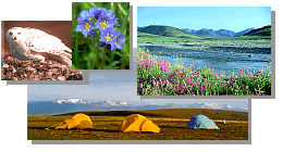
Wildlife: The Arctic Refuge contains an impressive variety of arctic wildlife. Dominated by the rugged and majestic Brooks Range, the Refuge is vast and remote - domain of the wandering Porcupine Caribou herd, packs of wolves, hardy muskoxen, lone wolverines, flocks of snow geese, and other wilderness-dependent species.

The rich pageant of wildlife found within the Refuge includes more than 160 bird species, 36 kinds of land mammals, nine marine mammal species, and 36 types of fish.

Habitat: The Arctic Refuge is among the most complete, pristine, and undisturbed ecosystems on earth. Here coastal lagoons, barrier islands, arctic tundra, foothills, mountains, and boreal forests provide a combination of habitats, climate, and geography unmatched by any other northern conservation area - conditions that support the Refuge's diverse community of life.

People: The Arctic Refuge is a landscape like those that shaped America's unique heritage and culture - a place of reflection, beauty, and adventure. It's big and wild enough to make you feel like one of the old-time explorers - self- reliant, independent, and free.

The Refuge is an inspiration to nature enthusiasts, and a home to local Inupiat Eskimo and Gwich'in Indian communities. It is also a symbol, even for those who will never visit, of the link between wilderness and wildlife, and the need for both, now and in the future.

Refuges: where wildlife comes first

Refuge Information | Wildlife | Habitat | People
Home | New | Feedback | Index | Search

Why we archived the ANWR website at Mapcruzin.com

Note: This is the MapCruzin.com archive of the FWS Arctic National Wildlife Refuge website. In December, 2001 FWS took this website offline, making it unavailable to the public. It includes 90 plus pages of information and many maps. As of 2006 the important information contained in this, the original "unsanitized" version of the FWS website, has yet to return to the internet, so we will continue to maintain it here as a permanent archive to help inform activists and concerned citizens. If you find any broken links, please report them to me at [email protected] and I will attempt to make the repairs. January, 2008 update - A small part of the original information that was present in 2001 has made it back into the current ANWR website. There is also an archive that contains a small amount of the original information, but it is not readily available from the main website.

Click here to visit our homepage. Click here for NRDC's message about ANWR from Robert Redford.

For more information on why this website was "pulled," Check here. And, you can also view the maps of caribou calving areas that the FWS did not want you to see here.

January 29, 2008: Visit Our New ANWR News for Updates


This page should be cited as follows:

U.S. Fish and Wildlife Service. 2001. Potential impacts of proposed oil and gas
       development on the Arctic Refuge�s coastal plain: Historical overview and
       issues of concern. Web page of the Arctic National Wildlife Refuge,
       Fairbanks, Alaska. 17 January 2001. http://arctic.fws.gov/issues1.html


Archived by MapCruzin.com. Visit us at mapcruzin.com.

MapCruzin.com is an independent firm specializing in the publication of educational and research resources. We created the first U.S. based interactive toxic chemical facility maps on the internet in 1996 and we have been online ever since. Learn more about us and view some of our projects and services.

Contact Us

Report Broken Links

Advertise on MapCruzin

Follow on Facebook
News & Updates

Find: Maps, Shapefiles, GIS Software & More

MapCruzin Blog for updates, questions and answers
Blog Updates

More Blog Updates

Downloads

Google Earth Toxic Release Inventory (TRI) Maps
Lester Brown's Plan B 3.0
State GIS Shapefiles, Maps & Resources
GIS Shapefiles & Maps
GIS Programs, Tools & Resources
Free World Country & Regional Maps
GIS / GPS Careers and Job Positions
Disease Outbreak Maps
TOPO Maps
Extreme Weather & Disaster Maps
Free World Maps from the CIA Factbook
Arctic National Wildlife Refuge ANWR Maps
Oil and Gas Maps
Africanized Honey Bees
Renewable Energy Potential Maps of the United States
Terrorism Maps
War Maps
Google Maps
Weather Maps
GPS Resources
Historical Maps of the World
Google Earth
Library of Congress American Memory Map Downloads
Toxic Chemical Pollution Maps
Climate Change Maps
Toxic Release Inventory (TRI) Maps
Census Shapefiles
World Maps

Issues

Environmental Justice
Data Sources
Greenwash & JunkScience
Statistical Resources
Wireless Dangers
Surviving Climate Change
Global Right-To-Know
Creating Living Economies
Books of Note
Toxic Klamath River
Federal Lands Maps
TRI Analysis
TRI Webmaps
EnviroRisk Map Network
Community-Based Research
Right-To-Know or Left to Wonder?
Chemical Industry Archives
21st Century Warfare
Biotechnology
Nanotechnology
Globalization/Democracy
National Parks and Public Lands
Trade Secrets/Toxic Deception
GIS Books
Our Projects
Other Projects
1999 Archive Environews
Environmental Books
Environmental Links
Redwood Coast Information
Recycle, Salvage, Reuse

Resources
Shapefile Store
Free GIS Software
Free Map Downloads
Free Shapefiles
Free Remote Sensing
Free Topo Maps
Free GIS Tutorial
Free GPS
ToxicRisk.com
ClimateShift.com
Maptivist.com

About MapCruzin - Cookies, Privacy, Fair Use and Disclaimer - Advertise on MapCruzin.com

Copyright © 1996 - 2019 Michael Meuser, All Rights Reserved
MapCruzin is a Pop-Up Free Website -- Best Viewed With ANY Browser