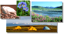
 ![[Arctic National Wildlife Refuge]](images/xtitle.gif.pagespeed.ic.uJfKRVzhSy.png)
Refuge Information | Wildlife | Habitat | People
Home | New | Feedback | Index
Why we archived the ANWR website at MapCruzin.com
Potential Impacts of Proposed Oil and Gas Development
on the Arctic Refuge's Coastal Plain: Historical Overview and Issues
of Concern
- Topics on this page:
- History of the Arctic Refuge as it relates to Oil in Alaska
How much Oil is in the Arctic Refuge?
The Unique Conservation Values of the Arctic Refuge
Potential Impacts of Oil and Gas Development on Refuge Resources
List of Reports
History of the Arctic Refuge as it relates to Oil in Alaska
 Interest in the oil resources of northern Alaska began with
reports in the early 1900s of surface oil seeps along the arctic coast east of Point
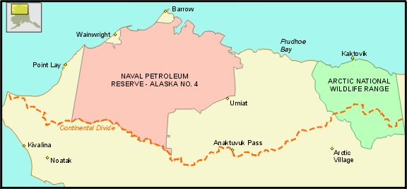
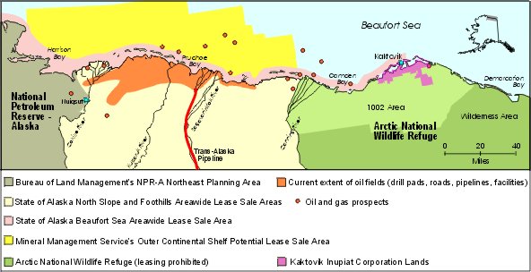
Barrow. In 1923, the 23-million acre Naval Petroleum Reserve No. 4 was established in
northwestern Alaska to secure a supply of oil for future national security needs. That
area was later renamed the National Petroleum Reserve-Alaska (NPR-A). Extensive
government-sponsored exploration for oil and gas occurred in the NPR-A during the 1940-1950s. Interest in the oil resources of northern Alaska began with
reports in the early 1900s of surface oil seeps along the arctic coast east of Point
Barrow. In 1923, the 23-million acre Naval Petroleum Reserve No. 4 was established in
northwestern Alaska to secure a supply of oil for future national security needs. That
area was later renamed the National Petroleum Reserve-Alaska (NPR-A). Extensive
government-sponsored exploration for oil and gas occurred in the NPR-A during the 1940-1950s.
During World War II, the entire North Slope of Alaska - 48.8 million acres - was
withdrawn from entry under the public land laws and thus held for exclusive use by
the U.S. government for military purposes.
 In the 1950s, post-war construction and accelerating resource development across Alaska
raised concerns about the potential loss of this region's special natural values.
In 1952-53, government scientists conducted a comprehensive survey of potential
conservation areas in Alaska. Their report, "The
Last Great Wilderness," identified the undisturbed northeast corner of Alaska as the
best opportunity for protection.
In the 1950s, post-war construction and accelerating resource development across Alaska
raised concerns about the potential loss of this region's special natural values.
In 1952-53, government scientists conducted a comprehensive survey of potential
conservation areas in Alaska. Their report, "The
Last Great Wilderness," identified the undisturbed northeast corner of Alaska as the
best opportunity for protection.
Two major consequences followed:
- In 1957, Secretary of Interior Fred Seaton of the Eisenhower Administration
revoked the previous military withdrawal on 20 million acres of the North Slope
of Alaska to make it available for commercial oil and gas leasing. This was in
addition to the previously established 23 million acre Naval Petroleum Reserve.
- In 1960, Secretary Seaton designated 8.9 million acres of coastal plain and
mountains of northeast Alaska as the Arctic National Wildlife Range to protect
its "unique wildlife, wilderness and recreation values."
These two actions laid out a general land use pattern for northern Alaska by
setting aside about 43 million acres for multiple land uses including oil and gas development,
while the northeastern corner was protected for wildlife and wilderness conservation.
Generalized view of land status by 1961. The majority of the tan area north of the
Continental Divide was ultimately selected by the State under the Alaska Statehood Act
(1959) or by Native Corporations established by the Alaska Native Claims Settlement Act (1971).
 The largest oil field in North America was discovered on state land in
the Prudhoe Bay area in 1968, and additional petroleum discoveries have more recently been made on Alaska's
North Slope. Oil is transported from the North Slope by the 800-mile Trans-Alaska Pipeline
System, from Prudhoe Bay to Valdez in south-central Alaska, where it is then transferred to oil tankers. The largest oil field in North America was discovered on state land in
the Prudhoe Bay area in 1968, and additional petroleum discoveries have more recently been made on Alaska's
North Slope. Oil is transported from the North Slope by the 800-mile Trans-Alaska Pipeline
System, from Prudhoe Bay to Valdez in south-central Alaska, where it is then transferred to oil tankers.
Reserves of oil were believed to also exist in the Arctic National Wildlife Range.
The fate of the Range was extensively debated in Congress for years before passage
of the Alaska National Interest Lands Conservation Act (ANILCA-1980).
The U.S. House of Representatives passed legislation in 1978 and 1979 designating
the entire original Range, including the now contested arctic coastal tundra, as
Wilderness. The Senate's version, however, required studies of wildlife and petroleum
resources, and the potential impacts of oil and gas development within the northern
part of the Range. It postponed the decision to authorize oil and gas development or
Wilderness designation. Differences between the House and Senate were not worked out
by a conference committee in the usual manner. Instead, following the 1980 election,
the House accepted the Senate bill and President Carter signed ANILCA into law. ANILCA
doubled the size of the Range, renamed it the Arctic National Wildlife Refuge, and
designated most of the original Range as Wilderness.
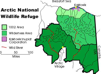
 The part of the original Range that was not designated Wilderness was addressed in Section
1002 of ANILCA, and is now referred to as the "1002 Area." Section 1002 outlined
additional information that would
be needed before Congress could designate the area as Wilderness, or permit oil development.
Studies of the 1002 Area included a
comprehensive inventory and assessment of the fish and wildlife resources, an analysis
of potential impacts of oil and gas exploration and development on those resources, and
a delineation of the extent and amount of potential petroleum resources.
The part of the original Range that was not designated Wilderness was addressed in Section
1002 of ANILCA, and is now referred to as the "1002 Area." Section 1002 outlined
additional information that would
be needed before Congress could designate the area as Wilderness, or permit oil development.
Studies of the 1002 Area included a
comprehensive inventory and assessment of the fish and wildlife resources, an analysis
of potential impacts of oil and gas exploration and development on those resources, and
a delineation of the extent and amount of potential petroleum resources.
In Section 1003 of ANILCA, Congress specifically stated that the "production of oil
and gas from the Arctic National Wildlife Refuge is prohibited and no leasing or other
development leading to production of oil and gas from the [Refuge] shall be undertaken
until authorized by an act of Congress."
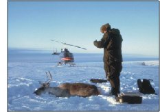
 The U.S. Fish and Wildlife Service conducted fish and wildlife
baseline studies of the 1002 Area beginning in 1981, and
the results were published in several volumes, culminating with a final report in
1986. During the winters of 1984 and 1985, seismic exploration was conducted along
1,400 miles of survey lines in the area. This work was conducted by a private
exploration firm and funded by a group of oil companies. Several oil companies
independently conducted other geological studies including surface rock
sampling, mapping and geochemical testing. Follow-up studies continued to assess the
impacts of the winter exploration program on fish and wildlife and their habitats. (See
references at the end of this web page.) The U.S. Fish and Wildlife Service conducted fish and wildlife
baseline studies of the 1002 Area beginning in 1981, and
the results were published in several volumes, culminating with a final report in
1986. During the winters of 1984 and 1985, seismic exploration was conducted along
1,400 miles of survey lines in the area. This work was conducted by a private
exploration firm and funded by a group of oil companies. Several oil companies
independently conducted other geological studies including surface rock
sampling, mapping and geochemical testing. Follow-up studies continued to assess the
impacts of the winter exploration program on fish and wildlife and their habitats. (See
references at the end of this web page.)
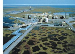
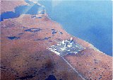
A land exchange completed in 1983 transferred the subsurface title of Kaktovik village
corporation lands (Kaktovik Inupiat Corporation (KIC)) from the Federal government
to the Arctic Slope Regional Corporation (a for-profit Native corporation
established by the Alaska Native Claims Settlement Act). This allowed for an
exploratory well to be drilled by industry in 1985 within the Refuge's boundary
on these private lands. The well was later plugged and abandoned, and the results
of the drilling operations remain confidential.
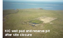 1990 photo of the KIC exploratory well drilled in 1985.
Information gathered from the biological, seismic and geological studies was
used to complete a Legislative Environmental Impact Statement (LEIS) that described
the potential impacts of oil and gas development. This LEIS included the Secretary's
final report and recommendation, and was submitted to Congress in 1987. The report
concluded that oil development and production in the 1002 Area would have major
effects on the Porcupine Caribou herd and muskoxen. Major effects were defined as
"widespread, long-term change in habitat availability or quality which would likely
modify natural abundance or distribution of species." Moderate effects were expected
for wolves, wolverine, polar bears, snow geese, seabirds and shorebirds, arctic
grayling and coastal fish. Major restrictions on subsistence activities by Kaktovik
residents would also be expected. In the report, the Secretary of Interior recommended
that Congress authorize an oil and gas leasing program that would avoid unnecessary
adverse effects on the environment.
Congress failed to act on the recommendation, first in 1989 following the Exxon
Valdez oil spill, and again in 1991 when a provision to open the Arctic Refuge to
development was dropped from the National Energy Policy Act. In 1995, Congress passed
budget legislation that included a provision to allow drilling in the Refuge.
Citing a desire to protect biological and wilderness values,
President Clinton vetoed the bill.
How much Oil is in the Arctic Refuge?
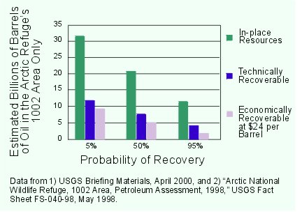 The U.S. Geological Survey (USGS) updated its estimates of potential petroleum resources
in the Refuge in 1998 by re-analyzing the original seismic data from 1984-1985 along
with more recent data from seismic surveys and drilling in adjacent areas. Using the
updated report and recent oil prices, the USGS estimated in 2000 that, assuming a price of
$24 per barrel, there is a 95% chance of finding 1.9 billion barrels (BBO) of
economically recoverable oil in the Arctic Refuge's 1002 Area; a 5% chance of
finding 9.4 BBO; and a 50% chance of finding 5.3 BBO. Reported estimates of 16 BBO from the
1002 Area and adjacent private lands and offshore State waters do not factor in the costs of
developing the oil field.
The U.S. Geological Survey (USGS) updated its estimates of potential petroleum resources
in the Refuge in 1998 by re-analyzing the original seismic data from 1984-1985 along
with more recent data from seismic surveys and drilling in adjacent areas. Using the
updated report and recent oil prices, the USGS estimated in 2000 that, assuming a price of
$24 per barrel, there is a 95% chance of finding 1.9 billion barrels (BBO) of
economically recoverable oil in the Arctic Refuge's 1002 Area; a 5% chance of
finding 9.4 BBO; and a 50% chance of finding 5.3 BBO. Reported estimates of 16 BBO from the
1002 Area and adjacent private lands and offshore State waters do not factor in the costs of
developing the oil field.
At prices less than $16 per
barrel, there is reportedly no economically recoverable oil in the 1002 Area. (Present oil
prices are ranging between $20 to $25 per barrel.) Nearly 1 million barrels of oil
a day are produced from the existing oil fields in areas west of the Arctic Refuge,
and new wells are brought into production each year.
Americans use 19 million barrels of oil each day, or 7 billion barrels of oil per year.
There is, therefore, a 50% chance of finding a 9 month's supply of oil in the 1002 Area,
at $24 per barrel.
Ongoing leasing activities and advancing oil recovery technologies on Alaska's
North Slope and Beaufort Sea continue to provide the industry with new opportunities
for exploration and development outside the boundaries of the Arctic Refuge.
The Unique Conservation Values of the Arctic Refuge
The Arctic National Wildlife Refuge is the largest unit in the National
Wildlife Refuge System. The Refuge is America's finest example of an intact, naturally
functioning community of arctic/subarctic ecosystems. Such a broad spectrum of diverse
habitats occurring within a single protected unit is unparalleled in North America, and
perhaps in the entire circumpolar north.
When the Eisenhower Administration established the original Arctic Range in 1960,
Secretary of Interior Seaton described it as:
"one of the world's great wildlife areas. The great diversity of vegetation and
topography in this compact area, together with its relatively undisturbed condition,
led to its selection as ... one of our remaining wildlife and wilderness frontiers."
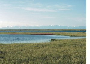
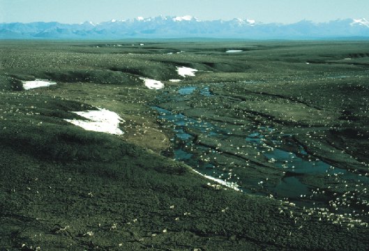
Within the Arctic Refuge, the Brooks Range mountains compress the coastal plain and
foothills tundra to a 20-40 mile wide band between the mountains and the sea.
In contrast, the
mountains further west rise far away from the Arctic Ocean coast, creating broad coastal
tundra ranging 100-200 miles north to south in the Prudhoe Bay and NPR-A areas.
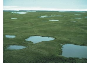
Although the 1002 Area is only 10% of the total Refuge acreage, it includes most of
the Refuge's coastal plain and arctic foothills ecological zones. The 1002 Area contains just 4%
of Alaska's coastal plain and foothills zones.
The Arctic Refuge is the only area on Alaska's
North Slope where petroleum development is specifically prohibited by Congress. The rest
of the region is available for oil and gas development through
administrative decisions by the Secretary of the Interior on NPR-A and the Beaufort Sea,
or by the Commissioner of the Alaska Department of Natural Resources on State lands and waters.
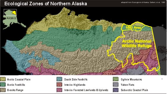
The 1002 Area is critically important to the ecological integrity of the whole Arctic
Refuge, providing essential habitats for numerous internationally important
species such as the Porcupine Caribou herd and polar bears. The compactness and proximity
of a number of arctic and subarctic ecological zones
in the Arctic Refuge provides for greater plant and animal diversity than in any other
similar sized land area on Alaska's North Slope.
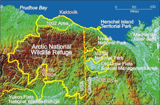
The Refuge is also an important part of a larger international network of protected
arctic and subarctic areas. In Canada's Yukon Territory, the government and First
Nations people protected the coastal tundra and adjacent mountains by establishing
Ivvavik and Vuntut National Parks, where oil exploration and production are not allowed.
Potential Impacts of Oil and Gas Development on Refuge Resources
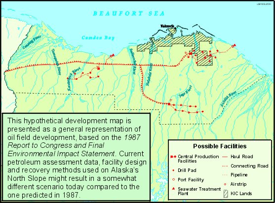
 Newer technologies that are applied today in Alaska's expanding North Slope oil
fields include directional drilling that allows for multiple well heads on smaller
drill pads; the re-injection of drilling wastes into the ground, which replaces
surface reserve pits; better delineation of oil reserves using 3-dimensional
seismic surveys, which has reduced the number of dry holes; and use of temporary
ice pads and ice roads for conducting exploratory drilling and construction in
the winter. As the oil fields expand east and west, additional oil reserves are
consequently being tapped from smaller satellite fields that rely on the existing
infrastructure at Prudhoe Bay and Kuparuk.
Newer technologies that are applied today in Alaska's expanding North Slope oil
fields include directional drilling that allows for multiple well heads on smaller
drill pads; the re-injection of drilling wastes into the ground, which replaces
surface reserve pits; better delineation of oil reserves using 3-dimensional
seismic surveys, which has reduced the number of dry holes; and use of temporary
ice pads and ice roads for conducting exploratory drilling and construction in
the winter. As the oil fields expand east and west, additional oil reserves are
consequently being tapped from smaller satellite fields that rely on the existing
infrastructure at Prudhoe Bay and Kuparuk.
Although technological
advances in oil and gas exploration and development have reduced some of the
harmful environmental effects associated with those activities, oil and gas
development remains an intrusive industrial process. The physical "footprint"
of the existing North Slope oil facilities and roads covers about 10,000 acres, but the current
industrial complex extends across an 800 square mile region, nearly 100 miles
from east to west. It continues to grow as new oil fields are developed.
The 100-mile wide 1002 Area is located more than 30 miles from the end
of the nearest pipeline and more than 50 miles from the nearest gravel road and oil
support facilities. According to the U.S. Geological Survey, possible
oil reserves may be located in many small accumulations in complex geological
formations, rather than in one giant field as was discovered at Prudhoe Bay.
Consequently, development in the 1002 Area could likely require a large number of
small production sites spread across the Refuge landscape, connected by an infrastructure
of roads, pipelines, power plants, processing facilities, loading docks, dormitories,
airstrips, gravel pits, utility lines and landfills.
 A substantial amount of water is needed for oil drilling, development,
and construction of ice roads. Water needed for
oil development ranges from eight to 15 million gallons over a 5-month period,
according to the Bureau of Land Management. If water is not available to build
ice roads, gravel is generally used. Water resources are limited in the 1002 Area. In winter,
only about nine million gallons of liquid water may be available in the entire 1002 Area, which
is enough to freeze into and maintain only 10 miles of ice roads. Therefore,
full development may likely require a network of permanent gravel pads and roads.
A substantial amount of water is needed for oil drilling, development,
and construction of ice roads. Water needed for
oil development ranges from eight to 15 million gallons over a 5-month period,
according to the Bureau of Land Management. If water is not available to build
ice roads, gravel is generally used. Water resources are limited in the 1002 Area. In winter,
only about nine million gallons of liquid water may be available in the entire 1002 Area, which
is enough to freeze into and maintain only 10 miles of ice roads. Therefore,
full development may likely require a network of permanent gravel pads and roads.
 Cumulative biological consequences of oil field development that may be expected in
the Arctic Refuge include:
Cumulative biological consequences of oil field development that may be expected in
the Arctic Refuge include:
- blocking, deflecting or disturbing wildlife
- loss of subsistence hunting opportunities
- increased predation by arctic fox, gulls and ravens on nesting birds due to
introduction of garbage as a consistent food source
- alteration of natural drainage patterns, causing changes in vegetation
- deposition of alkaline dust on tundra along roads, altering vegetation over
a much larger area than the actual width of the road
- local pollutant haze and acid rain from nitrogen oxides, methane and
particulate matter emissions
- contamination of soil and water from fuel and oil spills
Impacts of Winter Exploration
While the exploration of oil typically occurs during the winter months when caribou and
birds are absent from the 1002 Area, there are several arctic-adapted species that remain in
the area during winter would likely be affected, most notably muskoxen and polar bears, but
also wolverine, arctic fox, and arctic grayling. Winter exploration could also impact the
sensitive arctic tundra vegetation.
Muskoxen:
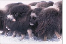 About 250 muskoxen live year-round in the 1002 area of the Arctic Refuge. They
use smaller areas in winter when snow limits available habitat. In order to
survive cold weather and poor forage conditions, muskoxen reduce their activity
and movements in winter to conserve energy. Muskoxen give birth four to six weeks
before summer forage is available. Therefore, females must maintain body fat throughout the
winter to successfully rear a calf. Calf production and animal survival is
influenced by environmental conditions such as snow depth and the length of the snow
season. In recent years, the number of muskox calves produced in the 1002 Area has
declined.
About 250 muskoxen live year-round in the 1002 area of the Arctic Refuge. They
use smaller areas in winter when snow limits available habitat. In order to
survive cold weather and poor forage conditions, muskoxen reduce their activity
and movements in winter to conserve energy. Muskoxen give birth four to six weeks
before summer forage is available. Therefore, females must maintain body fat throughout the
winter to successfully rear a calf. Calf production and animal survival is
influenced by environmental conditions such as snow depth and the length of the snow
season. In recent years, the number of muskox calves produced in the 1002 Area has
declined.
Muskoxen respond to predators and other disturbances by moving into a defensive
group from which they protect themselves with sharp horns. If groups are disturbed
enough, they will run. This can result in the deaths of
young calves that are left behind. Muskoxen in the 1002 Area are most frequently found
along or adjacent to large rivers flowing across the coastal plain.
During petroleum exploration and development, large rivers
are regularly used for gravel and water removal as well as transportation corridors. Concerns
associated with oil field activities along river corridors include:
- displacement of muskoxen from preferred winter habitat
- increased energy needs related to disturbance and displacement
- decreased body condition of females
- increased incidents of predation
- decreased calf production and animal survival
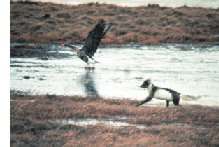
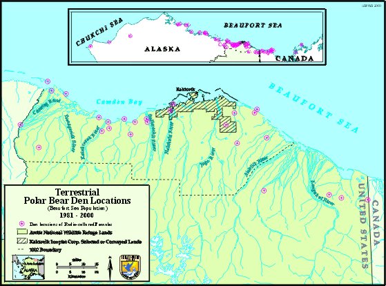
Polar Bear:
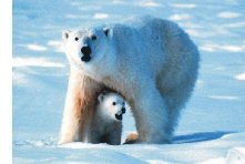 Female polar bears that are going to give birth to cubs build
dens in the winter. These females den on either ocean ice or on land, and those that den on
land choose sites along shoreline bluffs or along steep creek banks where snow drifts early
in the winter. The Arctic Refuge's coastal tundra provides the most important land denning habitat for the
Beaufort Sea polar bear population.
Female polar bears that are going to give birth to cubs build
dens in the winter. These females den on either ocean ice or on land, and those that den on
land choose sites along shoreline bluffs or along steep creek banks where snow drifts early
in the winter. The Arctic Refuge's coastal tundra provides the most important land denning habitat for the
Beaufort Sea polar bear population.
According to studies of radio-collared polar bears of the Beaufort Sea population between 1981
and 2000, 53 dens were located on the mainland coast of Alaska and Canada. Of these 53 dens,
22 (42%) were within the Arctic Refuge's 1002 Area.
Current seismic exploration methods require numerous vehicles to move in a grid pattern across the tundra.
Maternal polar bears with newborn cubs can be prematurely displaced from their winter dens
by the noise, vibrations and human disturbance associated with oil exploration activities. This
displacement may result in potentially fatal human-bear conflicts, and may expose the cubs to
increased mortality due to harsh winter conditions for which they are not yet prepared.
Vegetation:
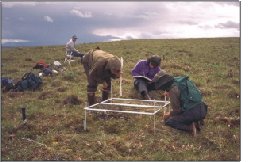
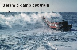
Seismic exploration involves sending sound waves into the ground, recording
how the sound reflects back, and interpreting the results to construct an image of
subsurface geology to determine if oil may be present. A seismic exploration
program on Alaska's North Slope is typically a large operation with many people and vehicles
driving across the tundra in a grid pattern. Although such exploration is
conducted only in winter, snow cover on the
1002 Area is often shallow and uneven, providing little protection for sensitive
tundra vegetation and soils. The impact from seismic vehicles and lines depends on the type of vegetation,
texture and ice content of the soil, the surface shape, snow depth, and type of vehicle.
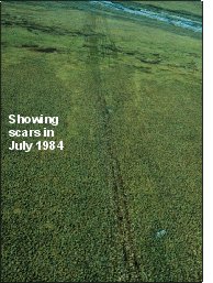
Two-dimensional (2-D) exploration was authorized by Congress in the 1002 Area in the winters of 1984 and
1985. Monitoring of more than 100 permanent plots along the 1,400 miles of seismic lines
has documented that while many areas recovered, some trails had still not recovered by 1999.
Some of the trails have become troughs visible from the air. Others show changes in the
amount and types of tundra plants. In some areas, permafrost (permanently frozen soil)
melted and the trails are wetter than they were previously.
 [1,400 miles of seismic lines were surveyed in the 1002 Area during
the winters of 1984 and 1985 to determine the amount and distribution of petroleum
resources.] [1,400 miles of seismic lines were surveyed in the 1002 Area during
the winters of 1984 and 1985 to determine the amount and distribution of petroleum
resources.]
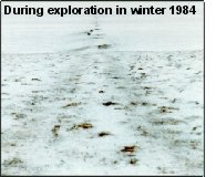
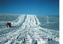 [Vehicles in March, 1985, compacted the snow and damaged underlying plants during seismic
exploration activities.]
[Vehicles in March, 1985, compacted the snow and damaged underlying plants during seismic
exploration activities.]
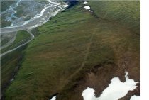 [A winter 1984 seismic trail in the 1002 Area seen in June 2000.]
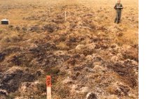 [Trail damage to tussock tundra the summer following winter seismic surveys.]
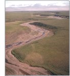
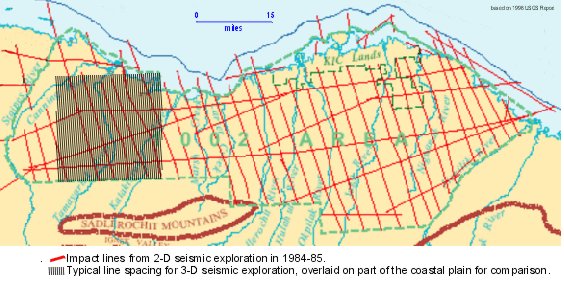
Seismic trail near Marsh Creek in the 1002 Area:
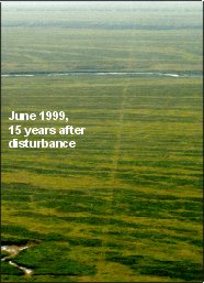
Seismic exploration is conducted every winter on the North Slope of Alaska,
west of the Refuge. New vehicle tracks and older ones in various stages of
recovery are visible on the tundra in the summer. Today, 3-dimensional
(3-D) seismic surveys, as conducted west of the Refuge
boundary, require a much more dense grid of lines to collect all the data
necessary for creating 3-D images of oil reserves. While the 1984-85 2-D
trails on the Arctic Refuge were 4 miles apart, 3-D trails would be one
half mile or less apart. The impact to vegetation
and soils on the Refuge would likely be much greater from 3-D seismic surveys
than from the 2-D seismic surveys conducted in the 1980s.
Impacts of Year-Round Oil Field Development
If winter exploration activities, including seismic surveys and drilling, find
economical amounts of oil, then full-scale construction and development of oil fields
might occur to produce oil and gas on a year-round basis. In addition to affecting
muskoxen, polar bears and other arctic-adapted resident species, oil and gas
production would likely also impact caribou and birds that migrate to the 1002 Area during the
brief summer period for calving and nesting.
Caribou:
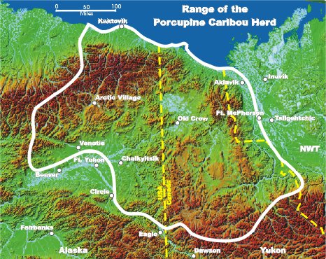
 In late spring, just as the snow recedes and the tundra plants turn green, the
Porcupine Caribou herd, numbering 129,000, migrates from south of the Brooks
Range in the Arctic Refuge and Canada to give birth to their young on the arctic
coastal tundra.
In late spring, just as the snow recedes and the tundra plants turn green, the
Porcupine Caribou herd, numbering 129,000, migrates from south of the Brooks
Range in the Arctic Refuge and Canada to give birth to their young on the arctic
coastal tundra.
The caribou's preferred food during calving season is higher in nutrition,
more digestible, and more available within the 1002 Area than in surrounding areas.
To successfully reproduce, female caribou must be able to move freely throughout the 1002 Area
to find adequate food resources to build up their fat reserves and milk. This allows
them to produce healthy calves. Cows with newborn calves are particularly sensitive, and commonly
move as much as 1.5 miles away from human disturbance. This has been
well-documented in the vicinity of existing North Slope oil fields.
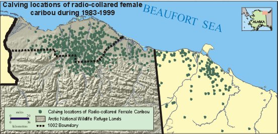
The Arctic Refuge's coastal tundra has been the birthing ground for the majority
of Porcupine Caribou cows in all but three of the last 18 years. In those 3 years
(1987, 1988 and 2000), snow remained on the tundra longer than usual, forcing the
caribou to have their calves in areas farther east or inland. Calf survival was
poorer in those years due to lower food nutrition and higher levels of predation.
Caribou populations naturally fluctuate in response to weather and forage conditions, and
all the arctic caribou herds in North America increased under favorable conditions in
the 1980s. There are fundamental differences between the calving areas of the Central
Arctic and the Porcupine herds. In the case of the Central
Arctic herd, there is a greater amount of alternative calving area available for
displaced cows to move to because the mountains are much farther from the ocean.
The 1002 Area is only one-fifth the size of the area used by the Central Arctic
caribou herd, but six times as many caribou use the 1002 Area. In the Arctic Refuge,
where the mountains are close to the coast, few alternative areas would be available
for displaced cows. If the 1002 Area was developed, the associated pipelines, roads,
and structures would potentially impact the Porcupine Caribou herd by:
- reducing the amount and quality of preferred forage available during and
after calving,
- restricting access to important coastal insect-relief habitats,
- exposing the herd to higher predation, and
- altering an ancient migratory pattern, the effects of which we can not predict.
A reduction in annual calf survival of as little as 5% would be sufficient to cause
a decline in the Porcupine caribou population.
Birds:
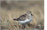 135 species of birds are known to use the 1002 Area, including numerous
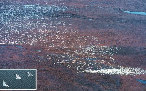
shorebirds, waterfowl, loons, songbirds, and raptors. One notable example is snow geese.
Large numbers of snow geese, varying from 15,000 to more than 300,000 birds, feed
on the Arctic Refuge coastal tundra for three to four weeks each fall, on their way from
nesting grounds on
Banks Island in Canada to wintering grounds primarily in California's Central Valley. They
feed on cottongrass and other plants to build up fat reserves in preparation for their
journey south, eating as much as a third of their body weight every day. The rich vegetation
of the coastal tundra enables them to increase fat reserves by 400% in only two to three weeks.
135 species of birds are known to use the 1002 Area, including numerous
shorebirds, waterfowl, loons, songbirds, and raptors. One notable example is snow geese.
Large numbers of snow geese, varying from 15,000 to more than 300,000 birds, feed
on the Arctic Refuge coastal tundra for three to four weeks each fall, on their way from
nesting grounds on
Banks Island in Canada to wintering grounds primarily in California's Central Valley. They
feed on cottongrass and other plants to build up fat reserves in preparation for their
journey south, eating as much as a third of their body weight every day. The rich vegetation
of the coastal tundra enables them to increase fat reserves by 400% in only two to three weeks.
Snow geese feed on small patches of vegetation that are widely distributed across the Refuge's
coastal tundra, so a large area is necessary to meet their needs. They are extremely
sensitive to disturbance, often flying away from their feeding sites when human
activities occur several miles distant.
For more specific information about the potential effects of oil and gas exploration and
development on Refuge resources, refer to the list of reports below. To learn more about
the Arctic Refuge and its unique wildlife and wilderness values, see our other web links...
Refuge Information | Wildlife | Habitat | People
Home | New | Feedback | Index
List of Reports
General Overview
Bird, K. J., and L.B. Magoon, eds. 1987. Petroleum geology of the northern
part of the Arctic National Wildlife Refuge, northeastern Alaska. U.S. Geological
Survey Bulletin 1778. 329 pp.
Clough, N.K., Patton, P.C., and Christiansen, A.C., eds. 1987. Arctic National
Wildlife Refuge, Alaska, coastal plain resource assessment - Report and
recommendation to the Congress of the United States and final legislative
environmental impact statement. U.S. Department of Interior, Washington D.C.
Garner, G.W., and P.E. Reynolds. 1986. Final report - baseline study of the
fish, wildlife, and their habitats. Arctic National Wildlife Refuge Coastal
Plain Resource Assessment. (several volumes). U.S. Department of Interior,
Fish and Wildlife Service, Anchorage, Alaska.
T. R. McCabe, B. Griffith, N. E. Walsh, and D. D. Young, editors. 1992.
Terrestrial Research: 1002 Area - Arctic NWR Interim Report 1988 - 1990.
U.S. Fish Wildlife Service, Anchorage, Alaska. 432 pp.
U.S. Fish and Wildlife Service. 1995. A Preliminary Review of the Arctic
National Wildlife Refuge, Alaska Coastal Plain Resource Assessment: Report and
Recommendation to the Congress of the United States and Final Legislative Environmental
Impact Statement. August 29, 1995. Report written for the Special Assistant to
the Secretary of the Interior for Alaska.
U.S. Geological Survey. 1999. The Oil and Gas Resource Potential of the Arctic
National Wildlife Refuge 1002 Area, Alaska. Open File Report 98-34 and Fact Sheet
FS-040-98. U.S. Department of the Interior, Geological Survey, Reston, VA.
Caribou
Ballard, W. B., M. A. Cronin, and H. A. Whitlaw. 2000. Caribou and oilfields.
Pages 85-104 in J. C. Truett and S. R. Johnson, editors. The natural history of
an arctic oil field�development and the biota. Academic Press. 422pp.
Cameron, R. D. 1995. Distribution and productivity of the Central Arctic Herd
in relation to petroleum development: case history studies with a nutritional
perspective. Federal Aid in Wildife Restoration Final Report. Alaska Department
of Fish and Game. Juneau. 35pp.
Cameron, R. D., and K. R. Whitten. 1979. Seasonal movements and sexual
segregation of caribou determined by aerial survey. Journal of Wildlife Management.
43:626-633.
Cameron, R. D., K. R. Whitten, W. T. Smith, and D. D. Roby. 1979.
Caribou distribution and group composition associated with construction of
the Trans-Alaska Pipeline. Canadian Field Naturalist. 93:155-162.
Cameron, R. D., D. J. Reed, J. R. Dau, and W. T. Smith. 1992. Redistribution
of calving caribou in response to oil field development on the arctic slope of
Alaska. Arctic 45:338-342.
Dau, J. R., and R. D. Cameron. 1986. Effects of a road system on caribou
distribution during calving. Rangifer, Special Issue No. 1:95-101.
Fancy, S. G., and K. R. Whitten. 1991. Selection of calving sites by Porcupine
herd caribou. Canadian Journal of Zoology. 69:1736-1743.
Nellemann, C., and R. D. Cameron. 1996. Terrain preferences of calving
caribou exposed to petroleum development. Arctic. 49:23-28.
Nellemann, C., and R. D. Cameron. 1998. Cumulative impacts of an evolving
oilfield complex on calving caribou. Canadian Journal of Zoology. 76:1425-1430.
Smith, W. T., and R. D. Cameron. 1985. Reactions of large groups of caribou
to a pipeline corridor on the arctic coastal plain of Alaska. Arctic. 38:53-57.
Smith, W. T., R. D. Cameron, and D. J. Reed. 1994. Distribution and movements
of caribou in relation to roads and pipelines, Kuparuk Development Area, 1978-1990.
Alaska Department of Fish and Game Wildlife Technical Bulletin. 12. 54pp.
Whitten, K. R., and R. D. Cameron. 1983. Movements of collared caribou,
Rangifer tarandus, in relation to petroleum development on the arctic slope of Alaska.
Canadian Field-Naturalist. 97(2):143-146.
Whitten, K. R., and R. D. Cameron. 1985. Distribution of caribou calving in
relation to the Prudhoe Bay oilfield. In: Martell, A. M., and D. E Russell, eds.
Proceedings of the First North American Caribou Workshop, Whitehorse, Yukon.
Ottawa: Canadian Wildlife Service. 33-39.
Whitten, K. R., G. W. Garner, F. J. Mauer, and R. B. Harris. 1992. Productivity
and early calf survival in the Porcupine caribou herd. Journal of Wildlife Management.
56:201-212
Muskox
Nellemann, C.H. and P.E. Reynolds. 1997. Terrain preferences associated with
patterns of late winter distribution of muskoxen (Ovibos moschatus). Arctic and
Alpine Research. 29(3).
O'Brien, C.M. 1988. Characterization of muskox habitat in northeastern Alaska.
M.S. thesis. University of Alaska, Fairbanks, Alaska.
Reynolds, P. E. 1992. Population dynamics of muskoxen on the Arctic Coastal Plain:
productivity and dispersal as a natural regulator of population size in the 1002 Area of
Arctic NWR. Pages 1-20 in T. R. McCabe, B. Griffith, N. E. Walsh, and D. D. Young,
editors. Terrestrial Research: 1002 Area - Arctic NWR Interim Report 1988 - 1990.
U.S. Fish Wildlife Service, Anchorage, Alaska. 432 pp.
Reynolds, P. E. 1992. Winter distribution, movements and habitat use of muskoxen
on potential petroleum lease areas of the Arctic NWR. Pages 130-147 in T. R. McCabe, B.
Griffith, N. E. Walsh, and D. D. Young, editors. Terrestrial Research: 1002 Area -
Arctic NWR Interim Report 1988 - 1990. U.S. Fish Wildlife Service, Anchorage, Alaska. 432 pp.
Reynolds, P.E. 1992. Seasonal differences in the distribution and movements of
muskoxen (Ovibos moschatus) in northeastern Alaska. Rangifer 12(3) pp 171-172.
Reynolds, P. E. 1993. Dynamics of muskox groups in northeastern Alaska.
Rangifer 13(2)83-89.
Reynolds, P.E. 1994. Muskoxen on the move: expansion of a re-established
population. Trans. of the 59th North American Wildlife Natural Resource
Conference 59 (abstract).
Reynolds, P. E. 1998. Dynamics and range expansion of a reestablished
muskox population. Journal of Wildlife Management 62:734-744.
Reynolds, P. E.1998. Ecology of a reestablished population of muskoxen in
northeastern Alaska. PhD thesis. University of Alaska, Fairbanks. 105pp.
Robus, M. A. 1981. Muskox habitat and use patterns in northeastern Alaska.
M.S. thesis, University of Alaska-Fairbanks, Fairbanks, AK. 116pp.
Wilson, K. J. 1992. Spatial scales of muskox resource selection in late
winter. M.S. thesis. University of Alaska, Fairbanks. 90pp.
Wilson, K. J., D. R. Klein, and P. E. Reynolds. 1992. Assessments of the
characteristics of muskox winter habitat in potential lease areas of the Arctic
NWR, Alaska. Pages 309-340 in T. R. McCabe, B. Griffith, N. E. Walsh, and D. D.
Young, editors. Terrestrial Research: 1002 Area - Arctic NWR Interim Report
1988 - 1990. U.S. Fish Wildlife Service, Anchorage, Alaska. 432 pp.
Polar Bear
Amstrup, S. C. 1993. Human disturbances of denning polar bears in Alaska.
Arctic 46:246-250.
Amstrup, S.C., and C. Gardner. 1994. Polar bear maternity denning in the
Beaufort Sea. Journal of Wildlife Management 58:1-10.
U.S. Fish and Wildlife Service. 1995. Habitat Conservation Strategy for Polar
Bears in Alaska. U.S. Fish and Wildlife Service, Alaska Region, Anchorage, Alaska.
Predators
Haugen, H. S. 1987. Den-site behavior, summer diet, and skull injuries of
wolves in Alaska. M.S. thesis. University of Alaska, Fairbanks. 205pp.
Phillips, M.K.1986. Behavior and habitat use of grizzly bears in northeastern
Alaska. M.S. thesis. University of Alaska, Fairbanks
Reynolds, H.V. and G.W. Garner. 1987. Patterns of grizzly bear predation on
caribou in northern Alaska. Proceedings International Conference on Bear Research
and Management. 7:59-67.
Weiler, G. J. and G. W. Garner. 1987. Wolves of the Arctic NWR: Their seasonal
movements and prey relationships. in G. Garner and P. Reynolds, editors. 1985
Update Rep. Baseline Study of Fish, Wildlife, and their Habitats. U. S. Fish and
Wildlife Service, Anchorage, Alaska 1281 pp.
Young, D. D., G. W. Garner, R. Ambrose, H. Reynolds, and T. R. McCabe. 1992.
Differential impacts of predators (brown bears, wolves, golden eagles) on caribou
calving in the 1002 Area and potential displacement areas: an assessment of
predation risks. Pages 37-66 in T. R. McCabe, B. Griffith, N. E. Walsh, and D.
D. Young, editors. Terrestrial Research: 1002 Area - Arctic NWR Interim Report
1988 - 1990. U.S. Fish Wildlife Service, Anchorage, Alaska. 432 pp.
Birds
Brackney, A. W. 1990. Distribution, abundance, and productivity of fall
staging snow geese on the coastal plain of the Arctic NWR, 1989. Pages 11-13
in T. R. McCabe, editor. Annual Wildlife Inventories: 1002 Area - Arctic NWR
Annual Progress Report 1989. U.S. Fish and Wildlife Service, Anchorage, Alaska.
Brackney, A. W. 1990. Abundance and productivity of tundra swans in the
coastal plain of the Arctic NWR, 1989. Pages 14-16 in T. R. McCabe, editor.
Annual Wildlife Inventories: 1002 Area - Arctic NWR Annual Progress Report 1989.
U.S. Fish and Wildlife Service, Anchorage, Alaska.
Brackney, A. W., and J. W. Hupp. 1993. Fall diet of Snow Geese staging in
northeastern Alaska. Journal of Wildlife Management. 57:55-61.
Hupp, J. W., and D. G. Robertson. 1992. Potential impacts of petroleum
development on Lesser Snow Geese staging on the Arctic Coastal Plain. Pages 207-230
in T. R. McCabe, B. Griffith, N. E. Walsh, and D. D. Young, editors. Terrestrial
Research: 1002 Area - Arctic NWR Interim Report 1988 - 1990. U.S. Fish Wildlife
Service, Anchorage, Alaska. 432 pp.
Hupp, J. W., and D. G. Robertson. 1998. Forage site selection by lesser snow
geese during autumn staging on the Arctic National Wildlife Refuge, Alaska. Wildlife
Monograph No. 138. 40 pp.
Martin, P. D., J. G. Kidd and D. C. Anthon. 1990. Migratory bird use of potential
port sites on the Beaufort sea coast of the Arctic NWR. Pages 1-18 in T. R. McCabe,
editor. Terrestrial Research: 1002 Area - Arctic NWR Annual Progress Report 1989.
U.S. Fish Wildlife Service, Anchorage, Alaska.
Monda, M., J. T. Ratti and T. R. McCabe. 1993. Behavioral responses of nesting
tundra swans to human disturbance and implications from nest predation on the Arctic
NWR. Proc. 14th Trumpeter Swan Society Conference. Courtenary, British Columbia,
Canada. p. 178 (Abstract)
Monda, M. J., J. T. Ratti, and T. R. McCabe. 1994. Reproductive ecology of tundra
swans on the Arctic NWR, Alaska. Journal of Wildlife Management. 58(4):757-773.
Monda, M., J. T. Ratti and T. R. McCabe. 1994. Modification of Tundra Swan habitat
by repeated use of nesting territories. Proc. 14th Trumpeter Swan Society Conference.
Courtenary, British Columbia, Canada. p. 179 (Abstract)
Monda, M..J. 1991. Reproductive ecology of tundra swans on the Arctic NWR. Ph.D.
thesis. Univ. Idaho, Moscow, Idaho. 94 pp.
Monda, M. J., J. T. Ratti, and T. R. McCabe. 1992. Reproductive ecology of tundra
swans on the Arctic NWR, Alaska. Pages 231-274 in T. R. McCabe, B. Griffith, N. E.
Walsh, and D. D. Young, editors. Terrestrial Research: 1002 Area - Arctic NWR
Interim Report 1988 - 1990. U.S. Fish Wildlife Service, Anchorage, Alaska. 432 pp.
Oates, R. M., P. D. Martin and D. C. Anthon. 1989. Migratory bird use of potential
port sites on the Beaufort sea coast of the Arctic NWR. Pages 1-32 in T. R. McCabe,
editor. Terrestrial Research: 1002 Area - Arctic NWR Annual Progress Report 1988.
U.S. Fish Wildlife Service, Anchorage, Alaska.
Willms, M. A. 1992. Arctic National Wildlife Refuge migratory bird use of potential
port sites, Final Report. U.S. Fish and Wildlife Service, Anchorage, Alaska. 126 pp.
Willms, M.A. and D.W. Crowley. 1992. Migratory birds use of potential port sites on
the Beaufort Sea coast of the Arctic NWR. Pages 1-28 in T. R. McCabe, B. Griffith,
N. E. Walsh, and D. D. Young, editors. Terrestrial Research: 1002 Area - Arctic NWR
Interim Report 1988 - 1990. U.S. Fish Wildlife Service, Anchorage, Alaska. 432 pp.
Fish
Underwood, T.J., J. A. Gordon, and B.M. Osborne. 1992. Fish population
characteristics of Arctic National Wildlife Refuge coastal waters, summer 1990.
Alaska Fisheries Progress Report Number 92-3. U.S. Fish and Wildlife Service,
Anchorage, Alaska.
Underwood, T. J., J. A. Gordon, L. A. Thorpe, and B. M. Osborne. 1994. Fish
population characteristics of Arctic National Wildlife Refuge coastal waters,
summer 1991. Alaska Fisheries Progress Report Number 94-1. U.S. Fish and Wildlife
Service, Anchorage, Alaska.
Underwood, T.J., J.A. Gordon, M. J. Millard, L.A. Thorpe, and B.M. Osborne.
1995. Characteristics of selected fish populations of the Arctic National Wildlife
Refuge Coastal Waters, Final Report, 1988-1991. Fisheries Technical Report Number 28.
U.S. Fish and Wildlife Service, Fairbanks Fishery Resource Office, Fairbanks, Alaska.
Underwood, T.J., M. J. Millard, and L.A. Thorpe. 1996. Characteristics of
Dolly Varden in nearshore waters of the Arctic National Wildlife Refuge, Alaska.
Transactions of the American Fisheries Society. 125:719-728.
Underwood, T.J., D.E. Palmer, L.A. Thorpe, and B.M. Osborne. 1997.
Weight-length relationships and the variation of Dolly Varden condition in
coastal waters of the Arctic National Wildlife Refuge, Alaska. American
Fisheries Society Symposium. 19:295-309.
Wiswar, D. W. 1991. Summer distribution of fishes in the Okpilak and
Akutoktak rivers, Arctic National Wildlife Refuge, Alaska 1989. Alaska
Fisheries Technical Report Number 11. U.S. Fish and Wildlife Service,
Fairbanks Fishery Resource Office, Fairbanks, Alaska.
Wiswar, D. W. 1992. Summer distribution of fishes in the Okpilak and Akutoktak,
Katakturuk, and Jago rivers, Arctic National Wildlife Refuge, Alaska 1990.
Alaska Fisheries Technical Report Number 17. U.S. Fish and Wildlife Service,
Fairbanks Fishery Resource Office, Fairbanks, Alaska.
Wiswar, D. W. 1994. Summer distribution of Arctic fishes in the 1002 area
of the Arctic National Wildlife Refuge, Alaska 1991 with special emphasis on
selected lakes, tundra streams, and the Sadlerochit river drainage. Alaska
Fisheries Technical Report Number 27. U.S. Fish and Wildlife Service, Fairbanks
Fishery Resource Office, Fairbanks, AK.
Wiswar, D.W., R. L. West, and W.N. Winkleman. 1995. Fisheries investigation
in Oruktalik Lagoon, Arctic Lagoon, Arctic National Wildlife Refuge, Alaska. 1986.
Alaska Fisheries Technical Report No. 27, U.S. Fish and Wildlife Service,
Fairbanks, Fishery Resource Office, Fairbanks, AK.
Vegetation
Felix, N. A. and M. K. Raynolds. 1988. The role of snow cover in limiting
surface disturbance caused by winter seismic exploration. Arctic 42(2):62-68.
Felix, N. A. and M. K. Raynolds. 1989. The effects of winter seismic trails
on tundra vegetation in northeastern Alaska, U.S.A. Arctic and Alpine Res. 21(2):188-202.
Raynolds, M. K. and N. A. Felix. 1989. Airphoto analysis of winter seismic
disturbance in northeastern Alaska. Arctic 42:(4)362-367.
Emers, M., J. C. Jorgenson, and M. K. Raynolds. 1995. Response of Arctic
plant communities to winter vehicle disturbance. Can. J. Botany 73: 905-919.
Emers M. and J. C. Jorgenson. 1996. Effects of winter seismic exploration
on the vegetation and soil thermal regime of the Arctic National Wildlife Refuge.
In Crawford, R. M. M. Ed., 1996. Disturbance and recovery in Arctic lands: an
ecological perspective. Kluwer Academic Publishers, Dordrecht, the Netherlands.
Water
Lyons, S. M., and J. M. Trawicki 1994. Water resource inventory and assessment,
coastal plain, Arctic National Wildlife Refuge: 1987-1992 Final Report. U.S. Fish
and Wildlife Service, Water Resource Branch Anchorage, AK. WRB 94-3.
Trawicki, J. M. , S. M. Lyons and G. V. Elliott. 1991. Distribution and
quantification of water within lakes of the 1002 area, Arctic National
Wildlife Refuge, Alaska. Alaska Fisheries Technical Report No. 10. U.S.
Fish and Wildlife Service, Anchorage, AK.
![[Refuges: where wildlife comes first]](images/xfooter.gif.pagespeed.ic.GRdEnLP6Xs.png)
Refuge Information | Wildlife | Habitat | People
Home | New | Feedback | Index
Why we archived the ANWR website at Mapcruzin.com
Note: This is the MapCruzin.com archive of the FWS Arctic National Wildlife Refuge website. In December, 2001 FWS took this website offline, making it unavailable to the public. It includes 90 plus pages of information and many maps. As of 2006 the important information contained in this, the original "unsanitized" version of the FWS website, has yet to return to the internet, so we will continue to maintain it here as a permanent archive to help inform activists and concerned citizens. If you find any broken links, please report them to me at [email protected] and I will attempt to make the repairs. January, 2008 update - A small part of the original information that was present in 2001 has made it back into the current ANWR website. There is also an archive that contains a small amount of the original information, but it is not readily available from the main website.
Click here to visit our homepage. Click here for NRDC's message about ANWR from Robert Redford.
For more information on why this website was "pulled," Check here. And, you can also view the maps of caribou calving areas that the FWS did not want you to see here.
 January 29, 2008: Visit Our New ANWR News for Updates January 29, 2008: Visit Our New ANWR News for Updates
This page should be cited as follows:
U.S. Fish and Wildlife Service. 2001. Potential impacts of proposed oil and gas
development on the Arctic Refuge�s
coastal plain: Historical overview and
issues of concern. Web page of the Arctic National
Wildlife Refuge,
Fairbanks, Alaska.
17 January 2001. http://arctic.fws.gov/issues1.html
Archived by MapCruzin.com. Visit us at mapcruzin.com.
MapCruzin.com is an independent firm
specializing in the publication of
educational and research resources.
We created the first U.S. based
interactive toxic chemical facility
maps on the internet in 1996 and we
have been online ever since. Learn more about us and view some of our projects and services.
Contact Us
Report Broken Links
| 


