GIS Shapefile Store - for Beginners & Experienced GIS Users Alike. Geographic Names Information System, Nuclear Facilities, Zip Code Boundaries, School Districts, Indian & Federal Lands, Climate Change, Tornadoes, Dams - Create digital GIS maps in minutes.
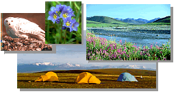
It is the Nation's largest and most northerly National Wildlife Refuge; South
Carolina could almost fit inside its borders.
Eight million acres are designated as Wilderness, more than on any other National
Wildlife Refuge.
The majestic Brooks Range rises from its coastal plain only 10-40 miles from the
Beaufort Sea.
It includes the four highest peaks and most of the glaciers in the Brooks Range.
There are 18 major rivers: three designated as Wild (Sheenjek, Ivishak, and Wind).
It includes three major physiographic areas (arctic tundra, Brooks Range, and boreal
forest), which contain a full range of arctic and subarctic habitats.
Numerous sites have been recommended as National Natural Landmarks.
It contains the greatest variety of plant and animal life of any conservation area in the
circumpolar north.
180 bird species from four continents have been seen there.
Peregrine falcons, endangered or threatened in the lower 48 states, are common there.
It is home to 36 species of land mammals.
It protects most of the calving grounds for the Porcupine caribou herd, the second
largest herd in Alaska.
It contains all three species of North American bears (black, brown, and polar).
Nine marine mammal species live along its coast.
36 fish species inhabit its rivers and lakes.
There are no roads, developments, or trails. You must fly, boat, or walk to get there.
The spirit of wilderness prevails there.
It offers outstanding scenery and recreation.
It is as primitive and undisturbed as any conservation area in the Nation.
It is home to North America's farthest north Dall sheep population.
It is the only national conservation area that provides a complete range of arctic
ecosystems.
It has two designated Research Natural Areas.
More than 300 archaeological sites have been found there.
It contains North America's two largest and most northerly alpine lakes (Peters and
Schrader).
Kaktovik, an Inupiaq Eskimo village, and Arctic Village, an Athabascan Indian
community, border its north and south sides.
Its coast is a major migration route for several waterfowl species.
Numerous prominent geological formations, including a range of permafrost and
glacial
features, are found there.
It contains several warm springs, which support plant species unique to the area.
The Nation's northernmost breeding population of golden eagles occurs there.
It borders two Canadian national parks.
It is used by two different caribou herds.
Continuous light prevails there from late April to mid-August; the sun stays below the
horizon from mid-November to mid-January.
It has no introduced species.
Permafrost underlies most of it, helping to keep the landscape wet and productive in
summer.
Huge fields of overflow ice ("aufeis") form along many of its rivers every winter.
It is open to public use year-round, offering unparalleled opportunities to experience
solitude, challenge, and adventure.
Note: This is the MapCruzin.com archive of the FWS Arctic National Wildlife Refuge website. In December, 2001 FWS took this website offline, making it unavailable to the public. It includes 90 plus pages of information and many maps. As of 2006 the important information contained in this, the original "unsanitized" version of the FWS website, has yet to return to the internet, so we will continue to maintain it here as a permanent archive to help inform activists and concerned citizens. If you find any broken links, please report them to me at [email protected] and I will attempt to make the repairs. January, 2008 update - A small part of the original information that was present in 2001 has made it back into the current ANWR website. There is also an archive that contains a small amount of the original information, but it is not readily available from the main website.
Click here to visit our homepage. Click here for NRDC's message about ANWR from Robert Redford.
U.S. Fish and Wildlife Service. 2001. Potential impacts of proposed oil and gas
development on the Arctic Refuge�s
coastal plain: Historical overview and
issues of concern. Web page of the Arctic National
Wildlife Refuge,
Fairbanks, Alaska.
17 January 2001. http://arctic.fws.gov/issues1.html
Archived by MapCruzin.com. Visit us at mapcruzin.com.
MapCruzin.com is an independent firm
specializing in the publication of
educational and research resources.
We created the first U.S. based
interactive toxic chemical facility
maps on the internet in 1996 and we
have been online ever since. Learn more about us and view some of our projects and services.


 January 29, 2008: