National Renewable Energy Laboratory (NREL) Solar Prospector Interactive Maps
<-- Download Free Maps
<-- Free Energy Maps & Shapefiles
If you are into solar energy, the National Renewable Energy Laboratory (NREL) offers an excellent tool for determining the best locations in the U.S. and Northern Mexico. Using the Solar Prospector interactive mapping tool you can examine and analyze solar data.
This information will help in locating the optimal locations for solar energy collection. Along with the solar data you can add layers including: ecoregions, flora and fauna, hydrology, land ownership, federal lands. Data is downloadable for use outside the tool.
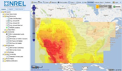
Visit the NREL Solar Prospector
<-- Download Free Maps
<-- Free Energy Maps & Shapefiles
Didn't find what you are looking for? We've been online since 1996 and have created 1000's of pages. Search below and you may find just what you are looking for.
Michael R. Meuser
Data Research & GIS Specialist
MapCruzin.com is an independent firm
specializing in GIS project development and data research.
We created the first U.S. based
interactive toxic chemical facility
maps on the internet in 1996 and we
have been online ever since. Learn more about us and our services.
Have a project in mind? If you have data, GIS project or custom shapefile needs contact Mike.
Contact Us
Report Broken Links
Subscribe for Updates


