Community Mapping Resources
Home   Store   Free GIS   Education   Free Shapefiles   Census   Weather   Energy   Climate Change   News   Maps   TOPO   Aerial   GPS   Learn GIS

DOWNLOAD SHAPEFILES: Canada FSA Postal - Zip Code - U.S. Waterbodies & Wetlands - Geographic Names - School Districts - Indian Federal Lands
Zip Code/Demographics - Climate Change - U.S. Streams, Rivers & Waterways - Tornadoes - Nuclear Facilities - Dams & Risk - 2013 Toxic Release Inventory TRI

ANWR Arctic National Wildlife Refuge; What is at stake; removed USFWS website; photos, maps, descriptions

tools for survival plans Maps Food Water Health Gardening Energy Housing Security Communications Livelihood

Money Making Tips Work from Home Make Money Used Lumber & Building Materal Beginner's Guide Buy/Sell Gold Electronics & Computer

GIS Shapefile Store - for Beginners & Experienced GIS Users Alike. Geographic Names Information System, Nuclear Facilities, Zip Code Boundaries, School Districts, Indian & Federal Lands, Climate Change, Tornadoes, Dams - Create digital GIS maps in minutes.

Toxic Release Inventory TRI Shapefiles

Canada FSA Postal Code Shapefile

GNIS Shapefiles 2,000,000+ Points

Nuclear Energy Facilities in the U.S.

Download Zip Code with Demographics Shapefiles

Download U.S. Streams & Rivers Shapefiles

Download Water Body & Wetland Shapefiles

Download Zip Code Boundary Shapefiles

Download School District Shapefiles

Download Indian & Federal Land Shapefiles

Download Climate Change Shapefiles

Download Tornado Shapefiles

Download Dams & Risks Shapefiles

Follow Mapcruzin.com on Twitter Follow on Twitter

Didn't find what you are looking for? Email me and I'll find it for you.

Progressive Links

Federation of American Scientists

Physicians for Social Responsibility

Public Employees for Environmental Responsibility

Union of Concerned Scientists

Alternet

Reader Supported News

Common Dreams

Truthout

Huffington Post

Media Matters

Think Progress

Grist Environmental News

Climate Shift Blog

MapCruzin Consulting
Data Research and GIS Specialists.

GIS Tutorials

GIS Basics

GIS Terminology

Of Interest

Arctic National Wildlife Refuge Maps

Climate Shift - The effects of climate shift on the future of planet earth and its inhabitants.

Right to Know or Left to Wonder?

Hazardscapes - Toxic and Nuclear Risks in your backyard.

War & Environment

Worst Case Scenarios: Terrorism & industrial chemicals.

geGIS Open Source Geo Data Ecosystem

Sponsors

<-- Free GIS Software & Resources

See Also:
Free ArcGIS Shapefiles, Free Maps, Google Earth & Maps, Free GPS, Satellite and Aerial, GIS Tutorials.

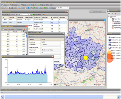
geGIS is an open source platform that allows you to manage your Geo Data using a standard browser.

How does geGIS work?

The geGIS architecture is obviously perfectly in keeping with the vision reflected in the geGIS concept, which may be summed up as follows:

  • Creating an ecosystem of servers for exchanging authentic source data over the Internet on an open and standard basis
  • Using this ecosystem as a medium for a new generation of geowindows based on high-performance Web 2.0 technology

geGIS first and foremost involves the management and exchange of authentic source data between equal servers. geGIS operates on the basis of the fact that myriad organisations are now compelled to entrust the actual administration of their data with so-called GIS "specialists". Our basic philosophy is that every IT organisation should be able to manage and exchange its own geodata. This calls for an architecture that differs drastically from Google Maps, for example, for which solely one central data manager is available. The exchange of geodata on equal terms is possible solely via a process of standardisation, thanks to the open GIS standards of the Open Geospatial Consortium. As well as putting these standards into practice geGIS forges further ahead: the layers developed may be deployed straightaway in a public geowindow.

Sponsors

The geGIS platform has been developed as a standard 3-tier J2EE application, where the presentation layer, the business layer and the data layer are fairly strictly separated from each other, conceived as separately maintainable modules. In the case of a Web application, the presentation layer primarily covers the web pages and JavaScript code. Featuring the system's central logic, the business layer comprises a Java code on the server which is addressed via a servlet. The data layer covers the persistent media (data base, shape files) and the access logic. We will now describe each of these layers in great detail.

Visit the geGIS Website.

<-- Free GIS Software & Resources

See Also:
Free ArcGIS Shapefiles, Free Maps, Google Earth & Maps, Free GPS, Satellite and Aerial, GIS Tutorials.

Didn't find what you are looking for? We've been online since 1996 and have created 1000's of pages. Search below and you may find just what you are looking for.


Michael R. Meuser
Data Research & GIS Specialist

MapCruzin.com is an independent firm specializing in GIS project development and data research. We created the first U.S. based interactive toxic chemical facility maps on the internet in 1996 and we have been online ever since. Learn more about us and our services.

Have a project in mind? If you have data, GIS project or custom shapefile needs contact Mike.

Contact Us

Report Broken Links

Subscribe for Updates

Sponsors

Follow on Facebook
News & Updates

Find: Maps, Shapefiles, GIS Software & More

MapCruzin Blog for updates, questions and answers
Blog Updates

More Blog Updates

Downloads

Google Earth Toxic Release Inventory (TRI) Maps
Lester Brown's Plan B 3.0
State GIS Shapefiles, Maps & Resources
GIS Shapefiles & Maps
GIS Programs, Tools & Resources
Free World Country & Regional Maps
GIS / GPS Careers and Job Positions
Disease Outbreak Maps
TOPO Maps
Extreme Weather & Disaster Maps
Free World Maps from the CIA Factbook
Arctic National Wildlife Refuge ANWR Maps
Oil and Gas Maps
Africanized Honey Bees
Renewable Energy Potential Maps of the United States
Terrorism Maps
War Maps
Google Maps
Weather Maps
GPS Resources
Historical Maps of the World
Google Earth
Library of Congress American Memory Map Downloads
Toxic Chemical Pollution Maps
Climate Change Maps
Toxic Release Inventory (TRI) Maps
Census Shapefiles
World Maps

Issues

Environmental Justice
Data Sources
Greenwash & JunkScience
Statistical Resources
Wireless Dangers
Surviving Climate Change
Global Right-To-Know
Creating Living Economies
Books of Note
Toxic Klamath River
Federal Lands Maps
TRI Analysis
TRI Webmaps
EnviroRisk Map Network
Community-Based Research
Right-To-Know or Left to Wonder?
Chemical Industry Archives
21st Century Warfare
Biotechnology
Nanotechnology
Globalization/Democracy
National Parks and Public Lands
Trade Secrets/Toxic Deception
GIS Books
Our Projects
Other Projects
1999 Archive Environews
Environmental Books
Environmental Links
Redwood Coast Information
Recycle, Salvage, Reuse

Resources
Shapefile Store
Free GIS Software
Free Map Downloads
Free Shapefiles
Free Remote Sensing
Free Topo Maps
Free GIS Tutorial
Free GPS
ToxicRisk.com
ClimateShift.com
Maptivist.com

About MapCruzin - Cookies, Privacy, Fair Use and Disclaimer - Advertise on MapCruzin.com

Copyright © 1996 - 2019 Michael Meuser, All Rights Reserved
MapCruzin is a Pop-Up Free Website -- Best Viewed With ANY Browser