Download Free Maps of Alabama
<-- Free Maps
<-- Free U.S. State Maps
<-- Free World Country Maps
See Also:
Topographic Maps
ArcGIS Shapefile Map Layers
Download or link to these maps for your reports, websites, research, projects, presentations...

Note that maps may not appear on the webpage in their full size and resolution. To save the maps to your computer, right-click on the link.
State Maps
Alabama (base map) JPEG format (451K) County boundaries and names, county seats, rivers. Original scale 1:2,500,000 U.S. Geological Survey, 1972 limited update 1990
Alabama (outline map) County boundaries and names. U.S. Bureau of the Census, 1990
Alabama (reference map) JPEG format (268K) Shaded relief map with state boundaries, forest cover, place names, major highways. Portion of "The National Atlas of the United States of America. General Reference", compiled by U.S. Geological Survey 2001, printed 2002
Alabama (reference map) PDF format (212K) Shaded relief map with state boundaries, forest cover, place names, major highways. Portion of "The National Atlas of the United States of America. General Reference", compiled by U.S. Geological Survey 2001, printed 2002
Alabama - Federal Lands and Indian Reservations PDF format (602K) The National Atlas of the United States of America, U.S. Geological Survey, 2003
City Maps
Albertville (topographic) original scale 1:24,000 U.S.G.S. 1983 (655K)
Alexander City (topographic) original scale 1:24,000 U.S.G.S. 1971 photorevised 1983 (621K)
Andalusia (topographic) original scale 1:24,000 U.S.G.S. 1971 photorevised 1986 (723K)
Athens (topographic) original scale 1:24,000 U.S.G.S. 1967 photorevised 1982 (663K)
Atmore (topographic) original scale 1:24,000 U.S.G.S. 1960 photorevised 1986 (323K)
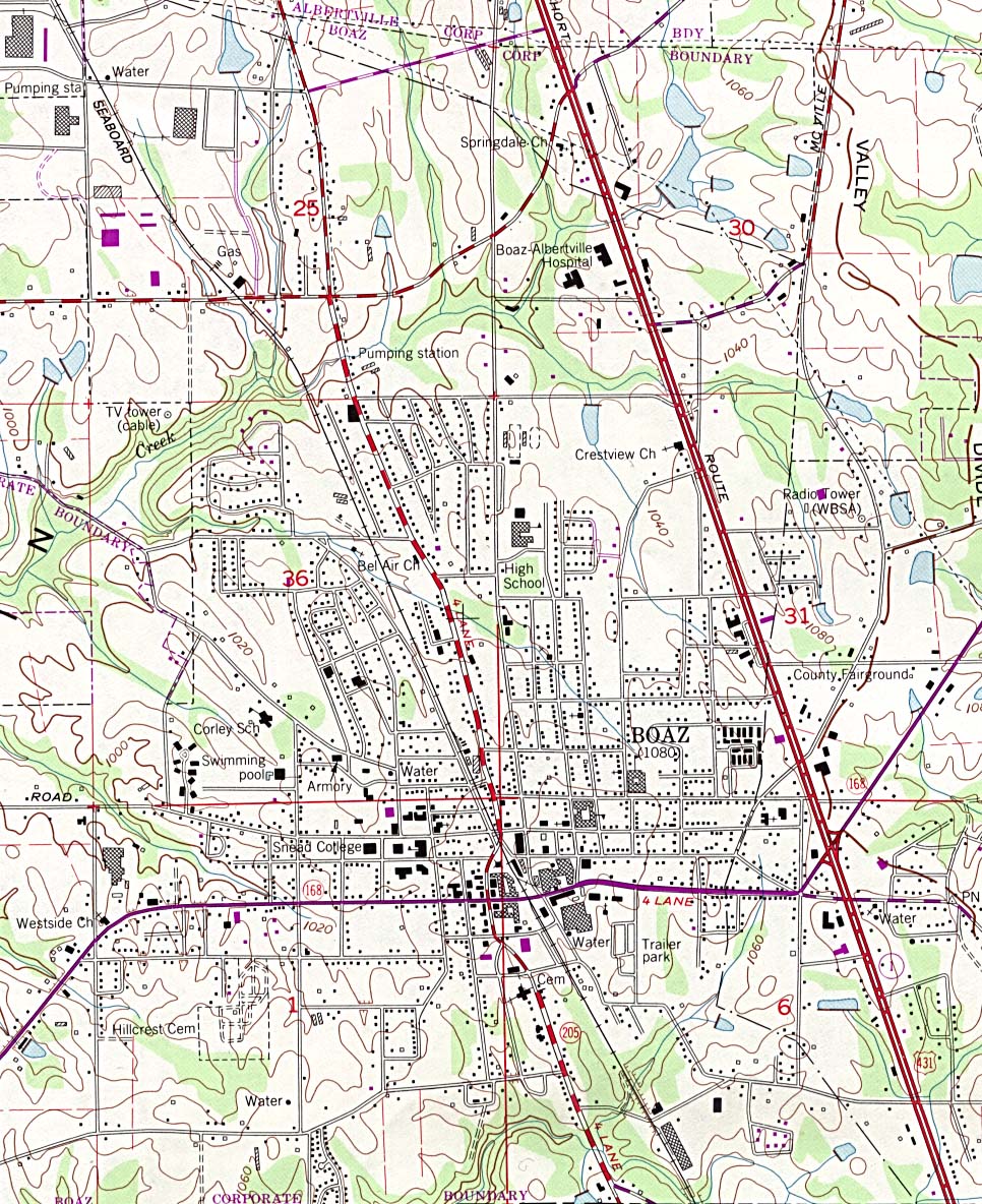
Boaz (topographic) original scale 1:24,000 U.S.G.S. 1983 (434K)
Cullman (topographic) original scale 1:24,000 U.S.G.S. 1957 photorevised 1983 (850K)
[Biloxi, Mississippi to Dauphin Island, Alabama] Biloxi Sheet, Metric Topographic Map 30088-A1-TM-100, U.S.G.S., 1982 (3.4MB)
Historical City Maps
Birmingham 1919 Automobile Blue Book, Volume 6, 1919 (130K)
Mobile 1815 "Mobile in 1815" From Report on the Social Statistics of Cities, Compiled by George E. Waring, Jr., United States. Census Office, Part II, 1886. (419K)
Decatur 1919 Automobile Blue Book, 1919, Vol. 6 (142K)
Mobile 1919 Automobile Blue Book, 1919, Vol. 6 (161K)
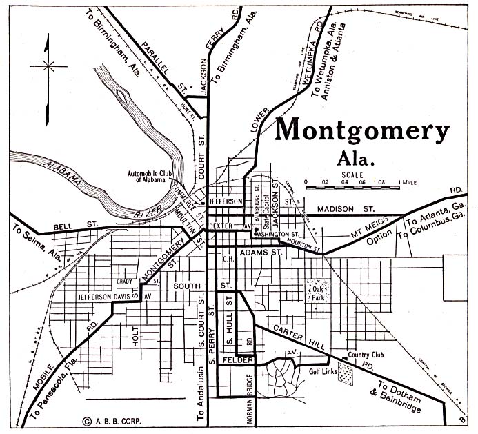
Montgomery 1920 Automobile Blue Book (137K)
Alabama Topographic Maps
Bellefontaine, Topographic Map Prototype, 1:24,000, U.S. Geological Survey, September 12, 2005 (495K)
Bon Becour Bay, Topographic Map Prototype, 1:24,000, U.S. Geological Survey, September 12, 2005 (521K)
Bridgehead, Topographic Map Prototype, 1:24,000, U.S. Geological Survey, September 12, 2005 (1.5MB)
Chickasaw, Topographic Map Prototype, 1:24,000, U.S. Geological Survey, September 12, 2005 (1.3MB)
Coden, Topographic Map Prototype, 1:24,000, U.S. Geological Survey, September 12, 2005 (1.4MB)
Daphne, Topographic Map Prototype, 1:24,000, U.S. Geological Survey, September 12, 2005 (1MB)
Elberta, Topographic Map Prototype, 1:24,000, U.S. Geological Survey, September 12, 2005 (1.1MB)
Elsanor, Topographic Map Prototype, 1:24,000, U.S. Geological Survey, September 12, 2005 (997K)
Foley, Topographic Map Prototype, 1:24,000, U.S. Geological Survey, September 12, 2005 (1.3MB)
Fort Morgan, Topographic Map Prototype, 1:24,000, U.S. Geological Survey, September 12, 2005 (361K)
Fort Morgan NW, Topographic Map Prototype, 1:24,000, U.S. Geological Survey, September 12, 2005 (315K)
Grand Bay, Topographic Map Prototype, 1:24,000, U.S. Geological Survey, September 12, 2005 (1.4MB)
Gulf Shores, Topographic Map Prototype, 1:24,000, U.S. Geological Survey, September 12, 2005 (1MB)
Heron Bay, Topographic Map Prototype, 1:24,000, U.S. Geological Survey, September 12, 2005 (565K)
Hollingers Island, Topographic Map Prototype, 1:24,000, U.S. Geological Survey, September 12, 2005 (748K)
Hurricane, Topographic Map Prototype, 1:24,000, U.S. Geological Survey, September 12, 2005 (1.3MB)
Little Dauphin Island, Topographic Map Prototype, 1:24,000, U.S. Geological Survey, September 12, 2005 (431K)
Magnolia Springs, Topographic Map Prototype, 1:24,000, U.S. Geological Survey, September 12, 2005 (1.6MB)
Mobile, Topographic Map Prototype, 1:24,000, U.S. Geological Survey, September 12, 2005 (1.6MB)
Petit Bois Pass, Topographic Map Prototype, 1:24,000, U.S. Geological Survey, September 12, 2005 (270K)
Pine Beach, Topographic Map Prototype, 1:24,000, U.S. Geological Survey, September 12, 2005 (398K)
Point Clear, Topographic Map Prototype, 1:24,000, U.S. Geological Survey, September 12, 2005 (612K)
Robertsdale, Topographic Map Prototype, 1:24,000, U.S. Geological Survey, September 12, 2005 (1MB)
Saint Andrews Bay, Topographic Map Prototype, 1:24,000, U.S. Geological Survey, September 12, 2005 (345K)
Saint Elmo, Topographic Map Prototype, 1:24,000, U.S. Geological Survey, September 12, 2005 (1.3MB)
Silverhill, Topographic Map Prototype, 1:24,000, U.S. Geological Survey, September 12, 2005 (1.4MB)
Theodore, Topographic Map Prototype, 1:24,000, U.S. Geological Survey, September 12, 2005 (1.6MB)
Maps of National Parks, Monuments, and Historic Sites
The following maps were produced by the U.S. National Park Service unless otherwise noted.
Gulf Islands National Seashore [Mississippi, Alabama, and Florida] (Detail and Park Maps) 1999 (387K) (PDF Format)
Gulf of Mexico [Mississippi, Alabama, and Florida] (Area Features) 1994 (351K)
Horseshoe Bend National Military Park (Creek Land Cessions 1733-1832 Map) (23K)
Horseshoe Bend National Military Park (The Creek War 1813-1814) (46K)
Horseshoe Bend National Military Park (Park Map) (230K)
Horseshoe Bend National Military Park (Park Map) (65K) (PDF Format)
Natchez Trace Parkway National Scenic Trail [Mississippi, Alabama, and Tennessee] (Area Map) 1999 (65K) (PDF Format)
Natchez Trace Parkway National Scenic Trail [Mississippi, Alabama, and Tennessee] (Park Map) 1999 (516K) (PDF Format)
Natchez Trace Parkway National Scenic Trail [Mississippi, Alabama, and Tennessee] (Natchez to Jackson, Mississippi) 1997 (387K)
Natchez Trace Parkway National Scenic Trail [Mississippi, Alabama, and Tennessee] (Jackson to Dancy, Mississippi) 1997 (323K)
Natchez Trace Parkway National Scenic Trail [Mississippi, Alabama, and Tennessee] (Dancy, Mississippi to Rock Spring, Alabama) 1997 (387K)
Natchez Trace Parkway National Scenic Trail [Mississippi, Alabama, and Tennessee] (Rock Spring, Alabama to Nashville, Tennessee) 1997 (452K)
Russell Cave National Monument (Area Map) 1995 (65K) (PDF Format)
Sources: Many of these maps were provided by the University of Texas Library and/or the U.S. Central Intelligence Agency (CIA).
Maps on other websites:
Alabama - County Road Maps (University of Alabama)
Alabama - County Names (Census Bureau)
Alabama - GIS Data Portal (Geological Survey of Alabama)
Alabama - Hurricane Katrina Maps
Alabama - Maps (Geology.com)
Alabama - Maps (Netstate)
Alabama - Maps (University of Alabama)
Alabama - Rivers (Alabama Division of Wildlife and Freshwater Fisheries)
Alabama - Road Map (World Sites Atlas)
Alabama - Satellite Image (Geology.com)
Alabama - Topographic Maps (Geological Survey of Alabama)
Alabama - Topographic Maps (Libre Map Project)
See Also:
Topographic Maps
ArcGIS Shapefile Map Layers
<-- Free Maps
<-- Free U.S. State Maps
<-- Free World Country Maps
Didn't find what you are looking for? We've been online since 1996 and have created 1000's of pages. Search below and you may find just what you are looking for.
Michael R. Meuser
Data Research & GIS Specialist
MapCruzin.com is an independent firm
specializing in GIS project development and data research.
We created the first U.S. based
interactive toxic chemical facility
maps on the internet in 1996 and we
have been online ever since. Learn more about us and our services.
Have a project in mind? If you have data, GIS project or custom shapefile needs contact Mike.
Contact Us
Report Broken Links
Subscribe for Updates
Sponsors
| 


![[Biloxi, Mississippi to Dauphin Island, Alabama]](/free-state-maps/states/alabama/biloxi_1982.jpg)
![Gulf of Mexico [Mississippi, Alabama, and Florida]](/free-state-maps/states/alabama/gulf94.jpg)
![Natchez Trace Parkway National Scenic Trail [Mississippi, Alabama, and Tennessee]](/free-state-maps/states/alabama/traceparkway4_97.jpg)
![Natchez Trace Parkway National Scenic Trail [Mississippi, Alabama, and Tennessee]](/free-state-maps/states/alabama/traceparkway3_97.jpg)
![Natchez Trace Parkway National Scenic Trail [Mississippi, Alabama, and Tennessee]](/free-state-maps/states/alabama/traceparkway2_97.jpg)
![Natchez Trace Parkway National Scenic Trail [Mississippi, Alabama, and Tennessee]](/free-state-maps/states/alabama/traceparkway1_97.jpg)