Free U.S. Nuclear Reactor Power Plant, Tornadoes from 1950 through 2008, G.E. BWR Mark I Like Fukushima and Those with Inadequate Spent Fuel Rod Cooling Power Backup
<-- All Things Nuclear
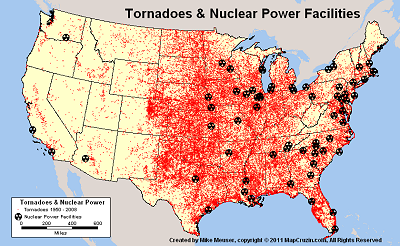
Nuclear Power Facilities and Tornadoes from 1950 to 2008
I created these maps after reading that two nuclear reactors shutdown during tornadoes last week. I wondered if backup power systems were adequate durng a prolonged extreme weather event. Note that there are currently 65 operating nuclear power facilities in the U.S. that have from 1 to 3 reactors each for a total of 104.
Large TIF Image
Medium PNG Image
PDF Format Map
shapefile coming soon
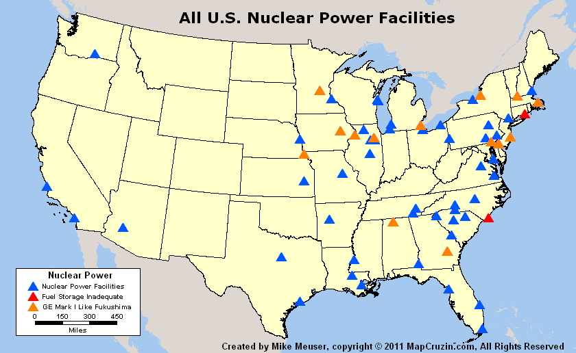
All U.S. Nuclear Facilities, Those Like Fukushima and Those With Inadequate Spent Fuel Rod Cooling Power Backup
Sponsors
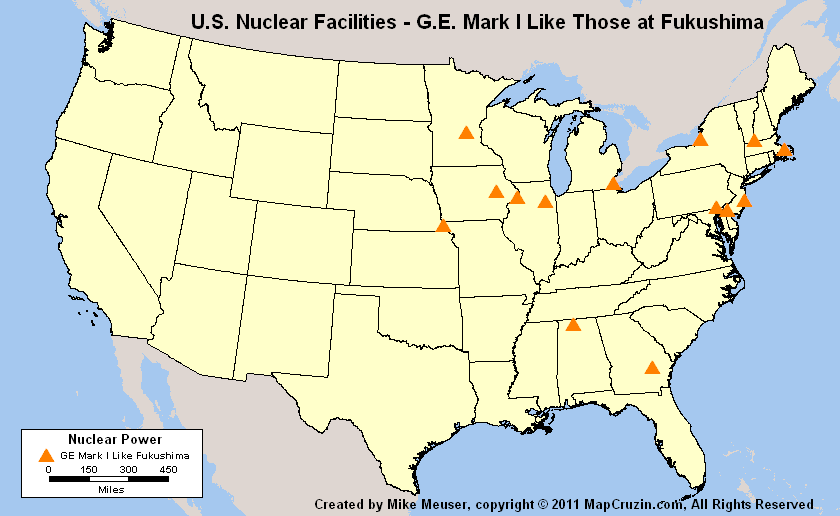
Recently Beyond Nuclear petitioned the U.S. NRC for suspension of 21 atomic reactor licenses in the wake of the Japanese Fukushima nuclear catastrophe. Beyond Nuclear alleges that the General Electric Boiling Water Reactor Mark 1 design�s weak containment, inadequate experimental venting back fit, and radioactive waste storage pool are accidents waiting to happen.
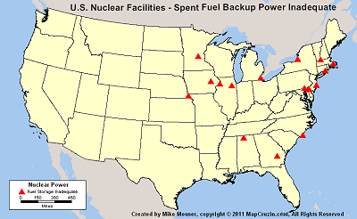
Beyond Nuclear has also petitioned the NRC for emergency enforcement action for G.E. boiling water reactors (BWR) that have Mark I primary containment systems and that do not have dedicated class E1 power for cooling elevated irradiated used fuel storage pools outside a rated containment structure. This petition include the above 21 reactors plus 3 more for a total of 24 (nearly 25% of U.S. reactors). I created the following 3 maps. Reactor lists follow the maps.

Large TIF Image
Medium PNG Image
PDF Format Map
shapefile coming soon

Large TIF Image
Medium PNG Image
PDF Format Map
shapefile coming soon
Browns Ferry 1, 2, and 3 (AL)
Cooper 1 (NE)
Dresden 2 & 3 (IL)
Duane Arnold 1(IA)
Fermi 2 (MI)
Fitzpatrick 1(NY)
Hatch 1 & 2 (GA)
Hope Creek 1 (NJ)
Monticello 1(MN)
Nine Mile Point 1 (NY)
Oyster Creek 1 (NJ)
Peach Bottom 2 & 3 (PA)
Pilgrim 1 (MA)
Quad Cities 1 & 2 (IL)
Vermont Yankee 1 (VT
Large TIF Image
Medium PNG Image
PDF Format Map
shapefile coming soon
BROWNS FERRY 1, 2 & 3 (AL)
BRUNSWICK 1 & 2 (NC)
COOPER 1 (NE)
DRESDEN 2 & 3 (IL)
DUANE ARNOLD 1 (IA)
FERMI 2 (MI)
FITZPATRICK 1 (NY)
HATCH 1 & 2 (GA)
HOPE CREEK 1 (NJ)
MONTICELLO 1 (MN)
MILLSTONE 1 (CT)
NINE MILE POINT 1 (NY)
OYSTER CREEK 1 (NJ)
PEACH BOTTOM 2 & 3 (PA)
PILGRIM 1 (MA)
QUAD CITIES 1 & 2 (IL)
VERMONT YANKEE 1 (VT)
If you require print quality maps or custom shapefiles of any sort, please contact me.
Sponsors
<-- All Things Nuclear
<-- Geospatial Data Shapefile Downloads
Didn't find what you are looking for? We've been online since 1996 and have created 1000's of pages. Search below and you may find just what you are looking for.
Michael R. Meuser
Data Research & GIS Specialist
MapCruzin.com is an independent firm
specializing in GIS project development and data research.
We created the first U.S. based
interactive toxic chemical facility
maps on the internet in 1996 and we
have been online ever since. Learn more about us and our services.
Have a project in mind? If you have data, GIS project or custom shapefile needs contact Mike.
Contact Us
Report Broken Links
Subscribe for Updates
Sponsors


