Download Free United States 80 Meter Green Renewable Wind Energy Maps by State
<-- Free Map Downloads
<-- Renewable Energy Maps & Shapefiles
 Our U.S. Renewable Wind Energy Resource Potential Maps can also be viewed and downloaded in a variety of sizes at flickr.com Our U.S. Renewable Wind Energy Resource Potential Maps can also be viewed and downloaded in a variety of sizes at flickr.com
These maps may be useful for alternative and renewable green energy research and education. Download by state.
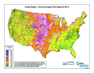

The United States wind map shows the wind energy resource at 80 meters. The zip file includes high resolution JPG images and PDFs of the map and chart plus a state-by-state XLS spreadsheet showing available wind energy, capacity installed and energy produced. Download the U.S. Wind Energy files (2.8mb).
Source: U.S. DOE Wind Powering America.
<-- Free Map Downloads
<-- Renewable Energy Maps & Shapefiles
Didn't find what you are looking for? We've been online since 1996 and have created 1000's of pages. Search below and you may find just what you are looking for.
Michael R. Meuser
Data Research & GIS Specialist
MapCruzin.com is an independent firm
specializing in GIS project development and data research.
We created the first U.S. based
interactive toxic chemical facility
maps on the internet in 1996 and we
have been online ever since. Learn more about us and our services.
Have a project in mind? If you have data, GIS project or custom shapefile needs contact Mike.
Contact Us
Report Broken Links
Subscribe for Updates
Sponsors
| 


