Geospatial Multi-Agency Coordination Group (GEOMAC) Maps of Current Fire Locations
Sponsors
<-- Fire Weather Wildfire Risk Maps
<-- Free Geography Maps
<-- Free U.S. State Shapefiles
<-- Free World Country Maps
GEOMAC Wildland fire Support: Geospatial Multi-Agency Coordination
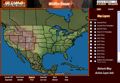
The Geospatial Multi-Agency Coordination Group or GeoMAC, is an internet-based mapping application originally designed for fire managers to access online maps of current fire locations and perimeters in the conterminous 48 States and Alaska. Using a standard web browser, fire personnel can view this information to pinpoint the affected areas. With the growing concern of western wildland fires in the summer of 2000, this application has also become available to the public. We hope that you find this important information both timely and helpful.
In order to give fire managers near real-time information, fire perimeter data is updated daily based upon input from incident intelligence sources, GPS data, infrared (IR) imagery from fixed wing and satellite platforms. The GeoMAC web site allows users in remote locations to manipulate map information displays, zoom in and out to display fire information at various scales and detail, and print hard copy maps for use in fire information and media briefings, dispatch offices and coordination centers. The fire maps also have relational databases in which the user can display information on individual fires such as name of the fire, current acreage and other fire status information.
Visit the Geospatial Multi-Agency Coordination Group website
<-- Fire Weather Wildfire Risk Maps
<-- Free Geography Maps
<-- Free U.S. State Shapefiles
<-- Free World Country Maps
Didn't find what you are looking for? We've been online since 1996 and have created 1000's of pages. Search below and you may find just what you are looking for.
Michael R. Meuser
Data Research & GIS Specialist
MapCruzin.com is an independent firm
specializing in GIS project development and data research.
We created the first U.S. based
interactive toxic chemical facility
maps on the internet in 1996 and we
have been online ever since. Learn more about us and our services.
Have a project in mind? If you have data, GIS project or custom shapefile needs contact Mike.
Contact Us
Report Broken Links
Subscribe for Updates
Sponsors
| 


