San Onofre Nuclear Reactor Shut Down Due to Leak
Sponsors

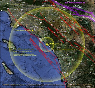
Map source: decommission.sanonofre.com
Tuesday afternoon, January 31, 2012, nuclear reactor at San Onofre nuclear power plant shut down due to a leak.
Of course, the plant operators say,
"The potential leak poses no imminent danger to the public or plant workers," according to a Southern California Edison statement. "There has been no release to the atmosphere."
Don't they always say that?
According to the SanClementPatch The leak was not big enough to trigger the automatic shutdown so crews shut it down manually at 5:31 p.m. Tuesday.
Tuesday evening crews worked to cool the reactor, enter the dome and repair the leak.
Nuclear reactor #1 was closed down permanently in 1992. Check the NRC website for details.
San Onofre power plant is situated on the West Coast between Los Angeles and San Diego. There are 8.4 million people within 50 miles of the facility. There is no feasible way that that many people could be evacuated in time to avoid risk if there were to be a catastrophic release.
Sponsors
Check here and CommonDreams.org for updates about the leak and shutdown of the San Onofre nuclear power plant.
Nuclear Resources
Free U.S. Nuclear Reactor Power Plant, Seismic Hazard and Historical Earthquakes ArcGIS Shapefile Maps, Images in TIF, PNG and PDF Formats.
Free U.S. Nuclear Reactor Power Plant, Tornadoes from 1950 through 2008, G.E. BWR Mark I Like Fukushima and Those with Inadequate Spent Fuel Rod Cooling Power Backup.
RadiationNetwork.com, home of the National Radiation Map, depicting environmental radiation levels across the USA, updated in real time every minute. This is the first web site where the average citizen (or anyone in the world) can see what radiation levels are anywhere in the USA at any time.

<-- GIS News
<-- GIS News
Didn't find what you are looking for? We've been online since 1996 and have created 1000's of pages. Search below and you may find just what you are looking for.
Michael R. Meuser
Data Research & GIS Specialist
MapCruzin.com is an independent firm
specializing in GIS project development and data research.
We created the first U.S. based
interactive toxic chemical facility
maps on the internet in 1996 and we
have been online ever since. Learn more about us and our services.
Have a project in mind? If you have data, GIS project or custom shapefile needs contact Mike.
Contact Us
Report Broken Links
Subscribe for Updates
Sponsors


