Free Wireless ArcGIS GIS Shapefile Map Layers
Sponsors
<-- Free GIS Software
<-- More Free GIS Shapefiles
<-- Wireless and Cell Phone Risks
See Also:
Congressional Hearings and EWG Reports about cell phone risks - Transcripts, videos, studies and documents.
Enter Any U.S. Address to Map Towers & Antennas
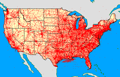
This is a map I created a few years ago that uses some of this data. There are tens of thousands of points. Click here for the complete project.
AM (zip, 0.32 MB, July, 2009)
Antenna Structure Registration (ASR) (zip, 12.2 MB, July, 2009)
Cellular (zip, 1.4 MB, July, 2009)
Cellular Service Area Boundaries (aggregate by callsign) (zip, 7.9 MB, July, 2009)
FM (zip, 1.1 MB, July, 2009)
Land Mobile - Commercial (zip, 4.2 MB, July, 2009)
Land Mobile - Private (zip, 37.6 MB, July, 2009)
Land Mobile - Broadcast (zip, 0.6 MB, July, 2009)
Microwave (zip, 11.9 MB, July, 2009)
Paging (zip, .68 MB, July, 2009)
TV - NTSC (zip, 0.47 MB, July, 2009)
TV - Digital (zip, 0.09 MB, July, 2009)
TV Contours NTSC & Digital (zip, 19.1 MB, July, 2009)
Learn More
Visit FCC's GIS website for more information.
Glossary of frequently used telecommunication terms.
Learn more about the FCC Universal Licensing System (ULS).
Glossary FCC Universal Licensing System.
Search the FCC Universal License System by city, state, zip, call letters and more - also provides geosearch capabilities.
Learn more about the FCC Antenna Registration Service (ASR).
Search the FCC antenna registration database by city, state and more and map the results.
FAQ for the FCC antenna registration database.
-------
Sponsors
About Shapefiles - Accuracy, Quality and Suitability
<-- Free GIS Software
<-- More Free GIS Shapefiles
<-- Wireless and Cell Phone Risks
See Also:
Congressional Hearings and EWG Reports about cell phone risks - Transcripts, videos, studies and documents.
Didn't find what you are looking for? We've been online since 1996 and have created 1000's of pages. Search below and you may find just what you are looking for.
Michael R. Meuser
Data Research & GIS Specialist
MapCruzin.com is an independent firm
specializing in GIS project development and data research.
We created the first U.S. based
interactive toxic chemical facility
maps on the internet in 1996 and we
have been online ever since. Learn more about us and our services.
Have a project in mind? If you have data, GIS project or custom shapefile needs contact Mike.
Contact Us
Report Broken Links
Subscribe for Updates
| 


