Community Mapping Resources
Home   Store   Free GIS   Education   Free Shapefiles   Census   Weather   Energy   Climate Change   News   Maps   TOPO   Aerial   GPS   Learn GIS

DOWNLOAD SHAPEFILES: Canada FSA Postal - Zip Code - U.S. Waterbodies & Wetlands - Geographic Names - School Districts - Indian Federal Lands
Zip Code/Demographics - Climate Change - U.S. Streams, Rivers & Waterways - Tornadoes - Nuclear Facilities - Dams & Risk - 2013 Toxic Release Inventory TRI

ANWR Arctic National Wildlife Refuge; What is at stake; removed USFWS website; photos, maps, descriptions

tools for survival plans Maps Food Water Health Gardening Energy Housing Security Communications Livelihood

Money Making Tips Work from Home Make Money Used Lumber & Building Materal Beginner's Guide Buy/Sell Gold Electronics & Computer

GIS Shapefile Store - for Beginners & Experienced GIS Users Alike. Geographic Names Information System, Nuclear Facilities, Zip Code Boundaries, School Districts, Indian & Federal Lands, Climate Change, Tornadoes, Dams - Create digital GIS maps in minutes.

Toxic Release Inventory TRI Shapefiles

Canada FSA Postal Code Shapefile

GNIS Shapefiles 2,000,000+ Points

Nuclear Energy Facilities in the U.S.

Download Zip Code with Demographics Shapefiles

Download U.S. Streams & Rivers Shapefiles

Download Water Body & Wetland Shapefiles

Download Zip Code Boundary Shapefiles

Download School District Shapefiles

Download Indian & Federal Land Shapefiles

Download Climate Change Shapefiles

Download Tornado Shapefiles

Download Dams & Risks Shapefiles

Follow Mapcruzin.com on Twitter Follow on Twitter

Didn't find what you are looking for? Email me and I'll find it for you.

Progressive Links

Federation of American Scientists

Physicians for Social Responsibility

Public Employees for Environmental Responsibility

Union of Concerned Scientists

Alternet

Reader Supported News

Common Dreams

Truthout

Huffington Post

Media Matters

Think Progress

Grist Environmental News

Climate Shift Blog

MapCruzin Consulting
Data Research and GIS Specialists.

GIS Tutorials

GIS Basics

GIS Terminology

Of Interest

Arctic National Wildlife Refuge Maps

Climate Shift - The effects of climate shift on the future of planet earth and its inhabitants.

Right to Know or Left to Wonder?

Hazardscapes - Toxic and Nuclear Risks in your backyard.

War & Environment

Worst Case Scenarios: Terrorism & industrial chemicals.

MapCruzinTM Learn2MapTM Tutorial and Atlas

Introduction - Startup - Sample Project
Your Project - Add More - Free GIS - Conclusion


4. YOUR FIRST MAP PROJECT

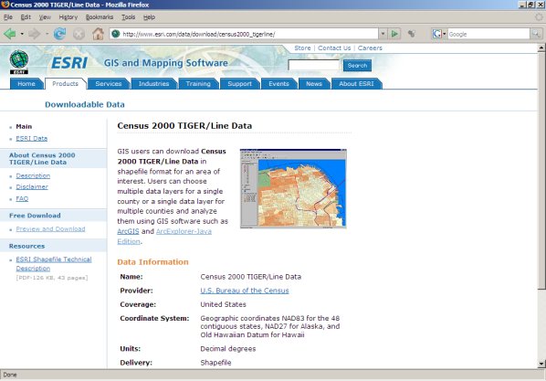
Now you will learn to create your own mapping project. To obtain the map layers for the county of our choice, go to:

www.esri.com/data/download/census2000-tigerline/


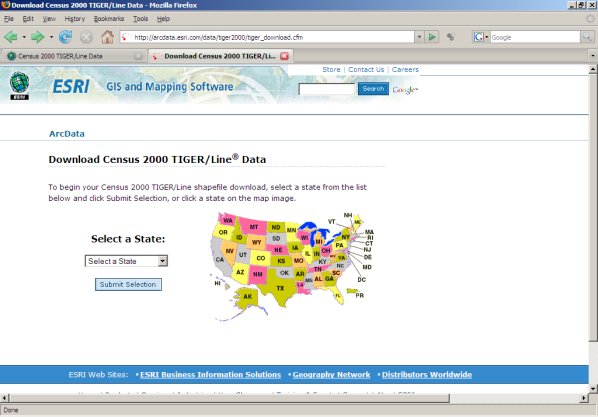
Click on the link "Preview and Download" on the left side of the page and you will be taken to a page with a U.S. map on it. Click on your state or pick it from the drop down menu.


On the following page select your county from the drop down menu.


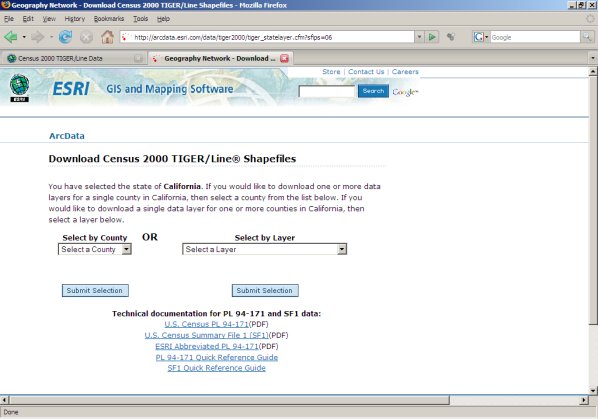
The next page will give you the option of selecting individual layers.


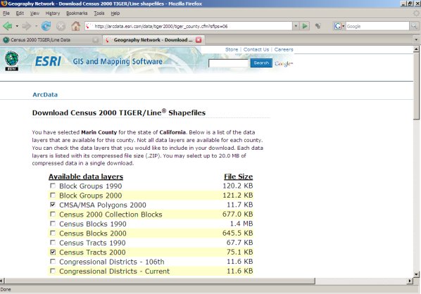
Make your choice(s) and click on "Proceed to Download" near the bottom of the page. When your file is ready you will see a new page. Note that there are other links at the bottom of the page. These documents will help you better understand the data that is contained in each of the layers.

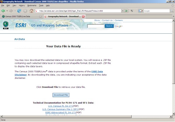
Scroll near the bottom of this page and click on "Download File Now." Save this file in your "mapcruzin_maps" directory. If you like, you can create a subdirectory like "tiger" or the county name or whatever name makes most sense to you. Note that this page also has links to several detailed discussions about the U.S. Census data.

Now go to the directory you chose and double-click on the file name (it will have a .zip extension). Jzip, a free program, will open (if you do not have Jzip, it can be downloaded from www.jzip.com. Do not mark any files just click on the extract button at the top of the page. A dialogue box will open. Navigate through the directories so that the file is extracted in the same directory.


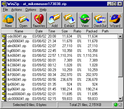
You will find a number of zip files. Each one corresponds to the layers you chose. You can now extract each one so they can be added to your new map. 
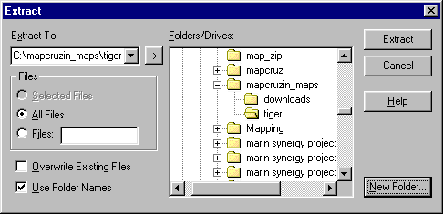
Click on "Extract" and work your way down to c:/mapcruzin_maps/, then click on "New Folder" and type in "tiger." This will extract all the files to a new directory, c:/mapcruzin_maps/tiger/.


To create a new map using these themes open ArcExplorer. Go to the menu item "Theme" and scroll down and click on "Add Theme."


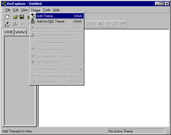
Navigate to the directory where you places the Tiger files downloaded above, click on a layer to highlight it, click on "Add Theme" and then on "Close." (Note that ArcExplorer will unzip these files for you).


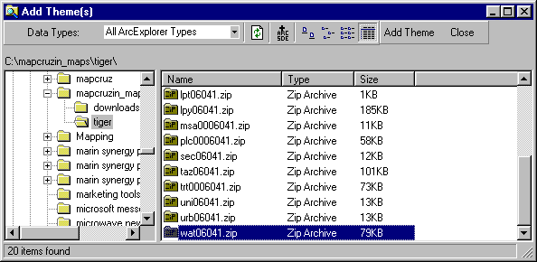
Note that you can add multiple themes all at once by either highlighting the top theme, scrolling down, holding down your "shift" key and highlighting the bottom theme or by selecting them individually by highlighting as you hold down the "ctrl" key.

You now see the theme(s) that you have added listed in the theme box to the left of the map window.


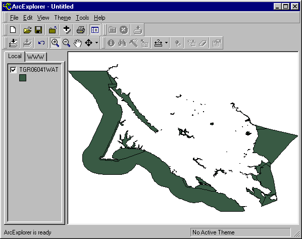
Recall that you can turn these off and on by checking or unchecking the box next to their name. To make a theme "active" so that you can view its related data with the "i" tool, you must click on its name. You can change the attributes of any theme by double-clicking on its name. You can change the order of the way themes are displayed on the map by placing your mouse over a theme's name, holding down your left button and dragging the theme up or down to its new position.

If you are interested in degree and certificate programs, check out Online GIS (Geographic Information System) Education Resources - Distance Learning for Bachelors, Masters, Certificates

Didn't find what you are looking for? We've been online since 1996 and have created 1000's of pages. Search below and you may find just what you are looking for.


Michael R. Meuser
Data Research & GIS Specialist

MapCruzin.com is an independent firm specializing in GIS project development and data research. We created the first U.S. based interactive toxic chemical facility maps on the internet in 1996 and we have been online ever since. Learn more about us and our services.

Have a project in mind? If you have data, GIS project or custom shapefile needs contact Mike.

Contact Us

Report Broken Links

Subscribe for Updates

Follow on Facebook
News & Updates

Find: Maps, Shapefiles, GIS Software & More

MapCruzin Blog for updates, questions and answers
Blog Updates

More Blog Updates

Downloads

Google Earth Toxic Release Inventory (TRI) Maps
Lester Brown's Plan B 3.0
State GIS Shapefiles, Maps & Resources
GIS Shapefiles & Maps
GIS Programs, Tools & Resources
Free World Country & Regional Maps
GIS / GPS Careers and Job Positions
Disease Outbreak Maps
TOPO Maps
Extreme Weather & Disaster Maps
Free World Maps from the CIA Factbook
Arctic National Wildlife Refuge ANWR Maps
Oil and Gas Maps
Africanized Honey Bees
Renewable Energy Potential Maps of the United States
Terrorism Maps
War Maps
Google Maps
Weather Maps
GPS Resources
Historical Maps of the World
Google Earth
Library of Congress American Memory Map Downloads
Toxic Chemical Pollution Maps
Climate Change Maps
Toxic Release Inventory (TRI) Maps
Census Shapefiles
World Maps

Issues

Environmental Justice
Data Sources
Greenwash & JunkScience
Statistical Resources
Wireless Dangers
Surviving Climate Change
Global Right-To-Know
Creating Living Economies
Books of Note
Toxic Klamath River
Federal Lands Maps
TRI Analysis
TRI Webmaps
EnviroRisk Map Network
Community-Based Research
Right-To-Know or Left to Wonder?
Chemical Industry Archives
21st Century Warfare
Biotechnology
Nanotechnology
Globalization/Democracy
National Parks and Public Lands
Trade Secrets/Toxic Deception
GIS Books
Our Projects
Other Projects
1999 Archive Environews
Environmental Books
Environmental Links
Redwood Coast Information
Recycle, Salvage, Reuse

Resources
Shapefile Store
Free GIS Software
Free Map Downloads
Free Shapefiles
Free Remote Sensing
Free Topo Maps
Free GIS Tutorial
Free GPS
ToxicRisk.com
ClimateShift.com
Maptivist.com

About MapCruzin - Cookies, Privacy, Fair Use and Disclaimer - Advertise on MapCruzin.com

Copyright © 1996 - 2019 Michael Meuser, All Rights Reserved
MapCruzin is a Pop-Up Free Website -- Best Viewed With ANY Browser