Offshore Oil Spill Maps, Software and GIS Shapefiles
<-- Free GIS Software & Resources
<-- Deepwater Horizon Gulf Oil Spill
We are listing here a growing number of mapping and GIS resources related to offshore oil spills. Return soon for more maps, software and GIS shapefiles.
SkyTruth Remote Sensing Image Maps of Gulf Oil Spill - SkyTruth is monitoring the growing oil spill in the Gulf of Mexico using NASA/MODIS satellite imagery and publishing daily reports and analysis as the situation develops.
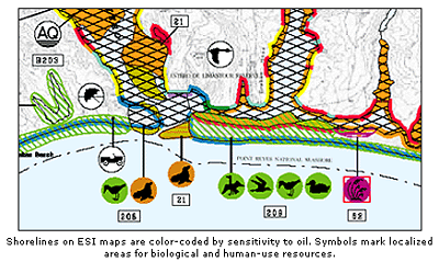
ESI - Deepwater Horizon Gulf Oil Spill Environmental Sensitivity Index (ESI) Atlases - ESI Viewers are free tools that you can use to view and query Environmental Sensitivity Index (ESI) atlases using the MARPLOT mapping program and a FileMaker application.
Learn More
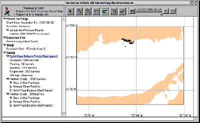
GNOME (General NOAA Operational Modeling Environment) is the oil spill trajectory model used by OR&R Emergency Response Division (ERD) responders during an oil spill.
Learn More
Sponsors
<-- Free GIS Software & Resources
<-- Deepwater Horizon Gulf Oil Spill
See Also:
Free ArcGIS Shapefiles, Free Maps, Google Earth & Maps, Free GPS, Satellite and Aerial, GIS Tutorials.
Didn't find what you are looking for? We've been online since 1996 and have created 1000's of pages. Search below and you may find just what you are looking for.
Michael R. Meuser
Data Research & GIS Specialist
MapCruzin.com is an independent firm
specializing in GIS project development and data research.
We created the first U.S. based
interactive toxic chemical facility
maps on the internet in 1996 and we
have been online ever since. Learn more about us and our services.
Have a project in mind? If you have data, GIS project or custom shapefile needs contact Mike.
Contact Us
Report Broken Links
Subscribe for Updates
| 


